|
|
|
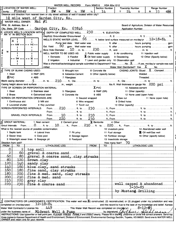
Specific Water Well Detail |
|
|
| Location Info | |||
| Owner: Mustang Drilling | Status: Constructed | ||
| Location: T24S, R33W, Sec. 14, SW NW NW | County: Finney | ||
| Directions: from Garden City, 1.25 mi W | |||
| Latitude: 37.9722905 | Longitude: -100.9184896 | Datum NAD 27 | |
| Latitude: 37.972314 | Longitude: -100.918931 | Datum NAD 83 | |
| Longitude and latitude calculated by Survey from township-range-section-quarter calls. Only good to within the quarter call accuracy. | |||
| View well on interactive map | |||
| General Info | ||
| Well Depth: 230 ft. | Elevation: ft. | |
| Static Water Level: 66 ft. | Est. Yield: 60 gpm. | |
| Comp. Date: 18-Dec-1984 | Well Use: Oil Field Water Supply | |
| DWR Applic. #: | Other ID: Mai 1 | |
| Driller Info | ||
| Driller: Midwest Well & Pump | License #: 449 | |
| Scanned Form | View scan |
|
Chemical Sample Submitted?: No
Water Well disinfected?: | ||
| Ground water encountered: 0 ft. , 0 ft. , 0 ft. | ||
| Pump test data: Well water was 0 ft after 0 hours pumping 0 gpm | ||
| Casing Info | ||
| Casing Type: PVC
Casing Joints: |
Diam: 5 in. to 210 ft
Diam: 0 in. to 0 ft Diam: 0 in. to 0 ft | |
| Casing height above land surface: in
Casing Weight: lbs/ft Wall thickness or gauge no.: | ||
| Screen and Perforation Info | ||
| Screen Type: PVC | Screen Openings: Saw cut | |
| Screen-perforated intervals | From: 210 ft to 230 ft
From: 0 ft to 0 ft From: 0 ft to 0 ft | |
| Gravel pack intervals | From: ft to ft | |
| Grout Info | ||
| Grout used: Bentonite | From: 0 to 10 ft
From: 210 to 220 ft From: 0 to 0 ft | |
| Source of Possible Contamination | ||
| Source: Oil well/gas well | ||
| Direction from well: | Distance: 0 ft | |
| Lithologic Log
(Log data entered by KGS.) | ||
| From: 0 ft. to 2 ft. | top soil | |
| From: 2 ft. to 60 ft. | gravel and coarse sand | |
| From: 60 ft. to 80 ft. | gravel and coarse sand, clay streaks | |
| From: 80 ft. to 120 ft. | brown clay | |
| From: 120 ft. to 140 ft. | sandy clay | |
| From: 140 ft. to 160 ft. | blue clay, sand streaks | |
| From: 160 ft. to 180 ft. | fine sand, clay streaks | |
| From: 180 ft. to 200 ft. | fine and medium sand, clay streaks | |
| From: 200 ft. to 210 ft. | fine and medium sand | |
| From: 210 ft. to 220 ft. | gray clay | |
| From: 220 ft. to 230 ft. | fine and coarse sand | |