|
|
|
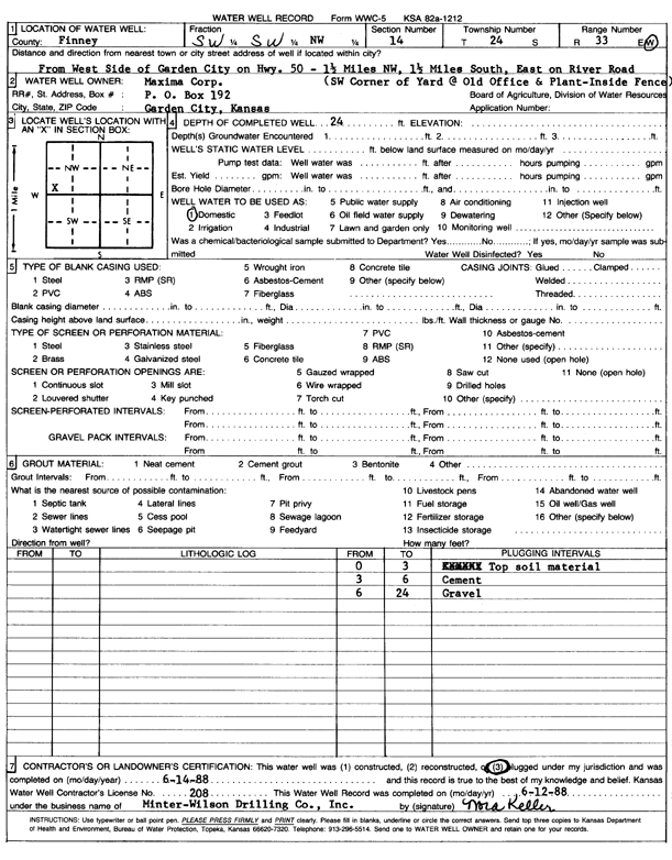
Specific Water Well Detail |
|
|
| Location Info | |||
| Owner: Maxima Corp. | Status: Plugged | ||
| Location: T24S, R33W, Sec. 14, SW SW NW | County: Finney | ||
| Directions: from W side: 1.5 mi NW on Hwy 50, 1.5 S, E on River Rd, SW corner of yard | |||
| Latitude: 37.9686897 | Longitude: -100.9185335 | Datum NAD 27 | |
| Latitude: 37.9687133 | Longitude: -100.918975 | Datum NAD 83 | |
| Longitude and latitude calculated by Survey from township-range-section-quarter calls. Only good to within the quarter call accuracy. | |||
| View well on interactive map | |||
| General Info | ||
| Well Depth: 24 ft. | Elevation: ft. | |
| Static Water Level: ft. | Est. Yield: gpm. | |
| Comp. Date: 14-Jun-1988 | Well Use: Domestic | |
| DWR Applic. #: | Other ID: | |
| Driller Info | ||
| Driller: MW Drilling | License #: 208 | |
| Scanned Form | View scan |
| Casing Info | ||
|
Casing Type:
Diam: 0 in. Casing height above land surface: in | ||
| Grout Info | ||
| Grout used: | From: 0 to 0 ft
From: 0 to 0 ft From: 0 to 0 ft | |
| Source of Possible Contamination | ||
| Source: | ||
| Direction from well: | Distance: 0 ft | |