|
|
|
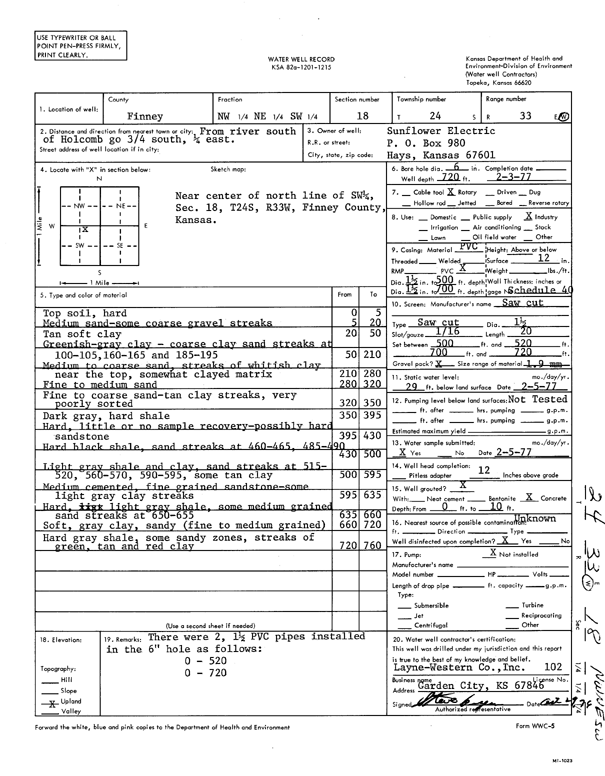
Specific Water Well Detail |
|
|
| Location Info | |||
| Owner: Sunflower Electric Power Corp. | Status: Constructed | ||
| Location: T24S, R33W, Sec. 18, NW NE SW | County: Finney | ||
| Directions: from river S of Holcomb, 0.75 mi S and 0.25 mi E | |||
| Latitude: 37.9664766 | Longitude: -100.9869295 | Datum NAD 27 | |
| Latitude: 37.9665007 | Longitude: -100.9873738 | Datum NAD 83 | |
| Longitude and latitude calculated by Survey from township-range-section-quarter calls. Only good to within the quarter call accuracy. | |||
| View well on interactive map | |||
| General Info | ||
| Well Depth: 720 ft. | Elevation: ft. | |
| Static Water Level: 29 ft. | Est. Yield: gpm. | |
| Comp. Date: 03-Feb-1977 | Well Use: Industrial | |
| DWR Applic. #: | Other ID: | |
| Links | |
| View info from Wizard Water Level Data base... | |
| No WIMAS information available. | |
| Driller Info | ||
| Driller: Layne-Christensen Co. | License #: 102 | |
| Scanned Form | View scan |
|
Chemical Sample Submitted?: Yes
Water Well disinfected?: | ||
| Ground water encountered: 0 ft. , 0 ft. , 0 ft. | ||
| Pump test data: Well water was 0 ft after 0 hours pumping 0 gpm | ||
| Casing Info | ||
| Casing Type:
Casing Joints: |
Diam: 0 in. to 0 ft
Diam: 0 in. to 0 ft Diam: 0 in. to 0 ft | |
| Casing height above land surface: in
Casing Weight: lbs/ft Wall thickness or gauge no.: | ||
| Screen and Perforation Info | ||
| Screen Type: | Screen Openings: | |
| Screen-perforated intervals | From: 500 ft to 520 ft
From: 700 ft to 720 ft From: 0 ft to 0 ft | |
| Gravel pack intervals | From: ft to ft | |
| Grout Info | ||
| Grout used: | From: 0 to 0 ft
From: 0 to 0 ft From: 0 to 0 ft | |
| Source of Possible Contamination | ||
| Source: | ||
| Direction from well: | Distance: 0 ft | |
| Lithologic Log
(Log data entered by KGS.) | ||
| From: 0 ft. to 5 ft. | top soil, hard | |
| From: 5 ft. to 20 ft. | medium sand - some coarse gravel streaks | |
| From: 20 ft. to 50 ft. | tan soft clay | |
| From: 50 ft. to 210 ft. | greenish-gray clay - coarse clay sand streaks at 100-105, 160-165 and 185-195 | |
| From: 210 ft. to 280 ft. | medium to coarse sand, streaks of whitish clay near the top, somewhat clayed matrix | |
| From: 280 ft. to 320 ft. | fine to medium sand | |
| From: 320 ft. to 350 ft. | fine to coarse sand - tan clay streaks, very poorly sorted | |
| From: 350 ft. to 395 ft. | dark gray, hard shale | |
| From: 395 ft. to 430 ft. | hard, little or no sample recovery- possibly hard sandstone | |
| From: 430 ft. to 500 ft. | hard black shale, sand streaks at 460-465, 485-490 | |
| From: 500 ft. to 595 ft. | light gray shale and clay, sand streaks at 515-520, 560-570, 590-595, some tan clay | |
| From: 595 ft. to 635 ft. | medium cemented, fine grained sandstone - some light gray clay streaks | |
| From: 635 ft. to 660 ft. | hard, light gray shale, some medium grained sand streaks at 650-655 | |
| From: 660 ft. to 720 ft. | soft, gray clay, sandy (fine to medium grained) | |
| From: 720 ft. to 760 ft. | hard gray shale, some sandy zones, streaks of green, tan and red clay | |