|
|
|
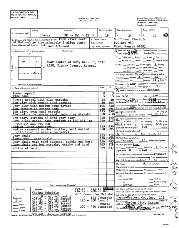
Specific Water Well Detail |
|
|
| Location Info | |||
| Owner: Sunflower Electric Power Corp. | Status: Constructed | ||
| Location: T24S, R33W, Sec. 19, SE NW SE | County: Finney | ||
| Directions: from river, 2 mi S and 0.75 mi E | |||
| Latitude: 37.9501958 | Longitude: -100.9802449 | Datum NAD 27 | |
| Latitude: 37.9502199 | Longitude: -100.980689 | Datum NAD 83 | |
| Longitude and latitude calculated by Survey from township-range-section-quarter calls. Only good to within the quarter call accuracy. | |||
| View well on interactive map | |||
| General Info | ||
| Well Depth: 714 ft. | Elevation: ft. | |
| Static Water Level: 71.1 ft. | Est. Yield: 800 gpm. | |
| Comp. Date: 09-Apr-1977 | Well Use: Industrial | |
| DWR Applic. #: | Other ID: | |
| Links | |
| View info from Wizard Water Level Data base... | |
| View info from WIMAS Water Right Data base... | |
| Driller Info | ||
| Driller: Layne-Christensen Co. | License #: 102 | |
| Scanned Form | View scan |
|
Chemical Sample Submitted?: Yes
Water Well disinfected?: | ||
| Ground water encountered: 0 ft. , 0 ft. , 0 ft. | ||
| Pump test data: Well water was 0 ft after 0 hours pumping 0 gpm | ||
| Casing Info | ||
| Casing Type:
Casing Joints: |
Diam: 0 in. to 0 ft
Diam: 0 in. to 0 ft Diam: 0 in. to 0 ft | |
| Casing height above land surface: in
Casing Weight: lbs/ft Wall thickness or gauge no.: | ||
| Screen and Perforation Info | ||
| Screen Type: | Screen Openings: | |
| Screen-perforated intervals | From: 479 ft to 699 ft
From: 0 ft to 0 ft From: 0 ft to 0 ft | |
| Gravel pack intervals | From: ft to ft | |
| Grout Info | ||
| Grout used: | From: 0 to 0 ft
From: 0 to 0 ft From: 0 to 0 ft | |
| Source of Possible Contamination | ||
| Source: | ||
| Direction from well: | Distance: 0 ft | |
| Lithologic Log
(Log data entered by KGS.) | ||
| From: 0 ft. to 5 ft. | brown topsoil | |
| From: 5 ft. to 15 ft. | fine sand | |
| From: 15 ft. to 50 ft. | coarse gravel with clay streaks | |
| From: 50 ft. to 105 ft. | tan clay with coarse sand streaks | |
| From: 105 ft. to 230 ft. | gray clay with medium sand layers | |
| From: 230 ft. to 295 ft. | tan, medium to coarse sand | |
| From: 295 ft. to 350 ft. | tan clay, some sand streaks | |
| From: 350 ft. to 410 ft. | tan medium to coarse sand, some clay streaks | |
| From: 410 ft. to 440 ft. | tan clay, streaks of hard gray clay | |
| From: 440 ft. to 615 ft. | hard black shale, sand streaks at 530-535, at 550-555 and 595-600 | |
| From: 615 ft. to 650 ft. | medium loose sandstone | |
| From: 650 ft. to 695 ft. | medium cemented sandstone - fine, well sorted (little or no sample recovery) | |
| From: 695 ft. to 720 ft. | gray shale | |
| From: 720 ft. to 730 ft. | sandy zone, gray shale | |
| From: 730 ft. to 765 ft. | gray shale with sand streaks, sticky and hard | |
| From: 765 ft. to 829 ft. | gray shale red bed streaks, sticky and hard | |