|
|
|
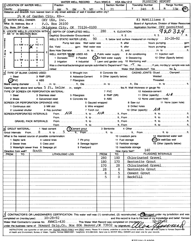
Specific Water Well Detail |
|
|
| Location Info | |||
| Owner: Oxy USA, Inc. | Status: Plugged | ||
| Location: T24S, R33W, Sec. 21, NW SW NE | County: Finney | ||
| Directions: from Garden City, 2.5 mi W | |||
| Latitude: 37.9556286 | Longitude: -100.9459494 | Datum NAD 27 | |
| Latitude: 37.9556524 | Longitude: -100.9463921 | Datum NAD 83 | |
| Longitude and latitude calculated by Survey from township-range-section-quarter calls. Only good to within the quarter call accuracy. | |||
| View well on interactive map | |||
| General Info | ||
| Well Depth: 280 ft. | Elevation: ft. | |
| Static Water Level: 90 ft. | Est. Yield: gpm. | |
| Comp. Date: 28-Oct-1992 | Well Use: Oil Field Water Supply | |
| DWR Applic. #: 920324 | Other ID: McWilliams E 3 | |
| Links | |
| No Wizard information available. | |
| View info from WIMAS Water Right Data base... | |
| Driller Info | ||
| Driller: Howard Drilling Co. | License #: 430 | |
| Scanned Form | View scan |
| Casing Info | ||
|
Casing Type: PVC
Diam: 5 in. Casing height above land surface: in | ||
| Grout Info | ||
| Grout used: Cement grout | From: 5 to 8 ft
From: 0 to 0 ft From: 0 to 0 ft | |
| Source of Possible Contamination | ||
| Source: Oil well/gas well | ||
| Direction from well: | Distance: 0 ft | |