|
|
|
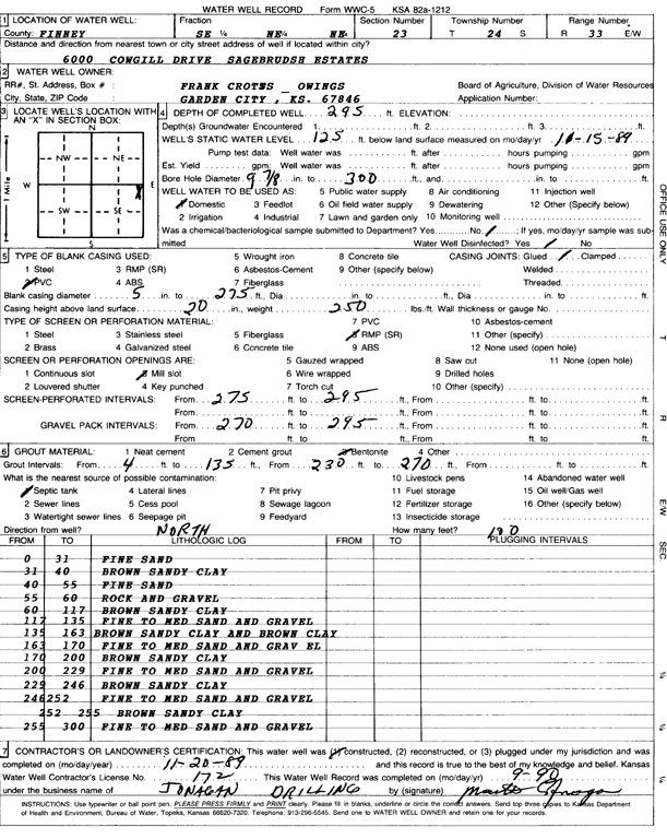
Specific Water Well Detail |
|
|
| Location Info | |||
| Owner: Crotes-Owings, Frank | Status: Constructed | ||
| Location: T24S, R33W, Sec. 23, SE NE NE | County: Finney | ||
| Directions: 600 Cowgill Dr, Sagebrush Estates | |||
| Latitude: 37.9573429 | Longitude: -100.9021326 | Datum NAD 27 | |
| Latitude: 37.9573663 | Longitude: -100.9025735 | Datum NAD 83 | |
| Longitude and latitude calculated by Survey from township-range-section-quarter calls. Only good to within the quarter call accuracy. | |||
| View well on interactive map | |||
| General Info | ||
| Well Depth: 295 ft. | Elevation: ft. | |
| Static Water Level: 125 ft. | Est. Yield: gpm. | |
| Comp. Date: 20-Nov-1989 | Well Use: Domestic | |
| DWR Applic. #: | Other ID: | |
| Driller Info | ||
| Driller: Jonagan Drilling Co. | License #: 172 | |
| Scanned Form | View scan |
|
Chemical Sample Submitted?: No
Water Well disinfected?: | ||
| Ground water encountered: 0 ft. , 0 ft. , 0 ft. | ||
| Pump test data: Well water was 0 ft after 0 hours pumping 0 gpm | ||
| Casing Info | ||
| Casing Type: PVC
Casing Joints: |
Diam: 5 in. to 275 ft
Diam: 0 in. to 0 ft Diam: 0 in. to 0 ft | |
| Casing height above land surface: in
Casing Weight: lbs/ft Wall thickness or gauge no.: | ||
| Screen and Perforation Info | ||
| Screen Type: RMP (SR) | Screen Openings: Mill slot | |
| Screen-perforated intervals | From: 275 ft to 295 ft
From: 0 ft to 0 ft From: 0 ft to 0 ft | |
| Gravel pack intervals | From: ft to ft | |
| Grout Info | ||
| Grout used: Bentonite | From: 4 to 135 ft
From: 230 to 270 ft From: 0 to 0 ft | |
| Source of Possible Contamination | ||
| Source: Septic Tank | ||
| Direction from well: | Distance: 0 ft | |
| Lithologic Log
(Log data entered by KGS.) | ||
| From: 0 ft. to 31 ft. | fine sand | |
| From: 31 ft. to 40 ft. | brown sandy clay | |
| From: 40 ft. to 55 ft. | fine sand | |
| From: 55 ft. to 60 ft. | rock and gravel | |
| From: 60 ft. to 117 ft. | brown sandy clay | |
| From: 117 ft. to 135 ft. | fine to medium sand and gravel | |
| From: 135 ft. to 163 ft. | brown sandy clay and brown clay | |
| From: 163 ft. to 170 ft. | fine to medium sand and gravel | |
| From: 170 ft. to 200 ft. | brown sandy clay | |
| From: 200 ft. to 229 ft. | fine to medium sand and gravel | |
| From: 229 ft. to 246 ft. | brown sandy clay | |
| From: 246 ft. to 252 ft. | fine to medium sand and gravel | |
| From: 252 ft. to 255 ft. | brown sandy clay | |
| From: 255 ft. to 300 ft. | fine to medium sand and gravel | |