|
|
|
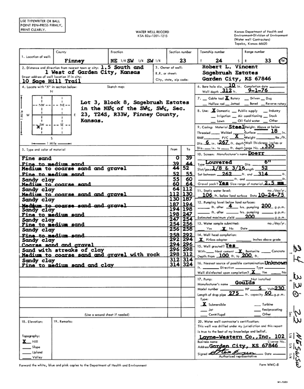
Specific Water Well Detail |
|
|
| Location Info | |||
| Owner: Vincent, Robert L. | Status: Constructed | ||
| Location: T24S, R33W, Sec. 23, NE SW SW | County: Finney | ||
| Directions: 10 Sage Hill Trail - 1.5 S, 1 W of Garden City | |||
| Latitude: 37.9487087 | Longitude: -100.9161475 | Datum NAD 27 | |
| Latitude: 37.9487323 | Longitude: -100.9165892 | Datum NAD 83 | |
| Longitude and latitude calculated by Survey from township-range-section-quarter calls. Only good to within the quarter call accuracy. | |||
| View well on interactive map | |||
| General Info | ||
| Well Depth: 312 ft. | Elevation: ft. | |
| Static Water Level: 106 ft. | Est. Yield: 200 gpm. | |
| Comp. Date: 01-Sep-1976 | Well Use: Domestic | |
| DWR Applic. #: | Other ID: | |
| Links | |
| View info from Wizard Water Level Data base... | |
| No WIMAS information available. | |
| Driller Info | ||
| Driller: Layne-Christensen Co. | License #: 102 | |
| Scanned Form | View scan |
|
Chemical Sample Submitted?: No
Water Well disinfected?: | ||
| Ground water encountered: 0 ft. , 0 ft. , 0 ft. | ||
| Pump test data: Well water was 0 ft after 0 hours pumping 0 gpm | ||
| Casing Info | ||
| Casing Type:
Casing Joints: |
Diam: 0 in. to 0 ft
Diam: 0 in. to 0 ft Diam: 0 in. to 0 ft | |
| Casing height above land surface: in
Casing Weight: lbs/ft Wall thickness or gauge no.: | ||
| Screen and Perforation Info | ||
| Screen Type: | Screen Openings: | |
| Screen-perforated intervals | From: 262 ft to 314 ft
From: 0 ft to 0 ft From: 0 ft to 0 ft | |
| Gravel pack intervals | From: ft to ft | |
| Grout Info | ||
| Grout used: | From: 0 to 0 ft
From: 0 to 0 ft From: 0 to 0 ft | |
| Source of Possible Contamination | ||
| Source: | ||
| Direction from well: | Distance: 0 ft | |
| Lithologic Log
(Log data entered by KGS.) | ||
| From: 0 ft. to 39 ft. | fine sand | |
| From: 39 ft. to 44 ft. | fine to medium sand | |
| From: 44 ft. to 52 ft. | medium to coarse sand and gravel | |
| From: 52 ft. to 55 ft. | fine to medium sand | |
| From: 55 ft. to 60 ft. | sandy clay | |
| From: 60 ft. to 64 ft. | medium to coarse sand | |
| From: 64 ft. to 112 ft. | sandy clay | |
| From: 112 ft. to 130 ft. | medium to coarse sand and gravel | |
| From: 130 ft. to 187 ft. | sandy clay | |
| From: 187 ft. to 194 ft. | medium to coarse sand and gravel | |
| From: 194 ft. to 198 ft. | sandy clay | |
| From: 198 ft. to 247 ft. | fine to medium sand | |
| From: 247 ft. to 254 ft. | sandy clay | |
| From: 254 ft. to 256 ft. | fine to medium sand | |
| From: 256 ft. to 258 ft. | sandy clay | |
| From: 258 ft. to 292 ft. | fine to medium sand | |
| From: 292 ft. to 294 ft. | sandy clay | |
| From: 294 ft. to 296 ft. | coarse sand and gravel | |
| From: 296 ft. to 298 ft. | sand with streaks of clay | |
| From: 298 ft. to 312 ft. | medium to coarse sand and gravel with rock | |
| From: 312 ft. to 314 ft. | sandy clay | |
| From: 314 ft. to 324 ft. | fine to medium sand and clay | |