|
|
|
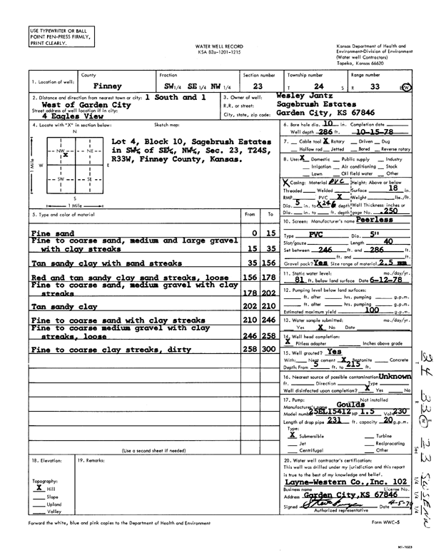
Specific Water Well Detail |
|
|
| Location Info | |||
| Owner: Jantz, Wesley | Status: Constructed | ||
| Location: T24S, R33W, Sec. 23, SW SE NW | County: Finney | ||
| Directions: 1 S, 1 W of Garden City - 4 Eagles View | |||
| Latitude: 37.9540983 | Longitude: -100.9138702 | Datum NAD 27 | |
| Latitude: 37.9541219 | Longitude: -100.9143117 | Datum NAD 83 | |
| Longitude and latitude calculated by Survey from township-range-section-quarter calls. Only good to within the quarter call accuracy. | |||
| View well on interactive map | |||
| General Info | ||
| Well Depth: 286 ft. | Elevation: ft. | |
| Static Water Level: 81 ft. | Est. Yield: 100 gpm. | |
| Comp. Date: 15-Oct-1978 | Well Use: Domestic | |
| DWR Applic. #: | Other ID: | |
| Driller Info | ||
| Driller: Layne-Christensen Co. | License #: 102 | |
| Scanned Form | View scan |
|
Chemical Sample Submitted?: No
Water Well disinfected?: | ||
| Ground water encountered: 0 ft. , 0 ft. , 0 ft. | ||
| Pump test data: Well water was 0 ft after 0 hours pumping 0 gpm | ||
| Casing Info | ||
| Casing Type:
Casing Joints: |
Diam: 0 in. to 0 ft
Diam: 0 in. to 0 ft Diam: 0 in. to 0 ft | |
| Casing height above land surface: in
Casing Weight: lbs/ft Wall thickness or gauge no.: | ||
| Screen and Perforation Info | ||
| Screen Type: | Screen Openings: | |
| Screen-perforated intervals | From: 246 ft to 286 ft
From: 0 ft to 0 ft From: 0 ft to 0 ft | |
| Gravel pack intervals | From: ft to ft | |
| Grout Info | ||
| Grout used: | From: 0 to 0 ft
From: 0 to 0 ft From: 0 to 0 ft | |
| Source of Possible Contamination | ||
| Source: | ||
| Direction from well: | Distance: 0 ft | |
| Lithologic Log
(Log data entered by KGS.) | ||
| From: 0 ft. to 15 ft. | fine sand | |
| From: 15 ft. to 35 ft. | fine to coarse sand, medium and large gravel with clay streaks | |
| From: 35 ft. to 156 ft. | tan sandy clay with sand streaks | |
| From: 156 ft. to 178 ft. | red and tan sandy clay sand streaks, loose | |
| From: 178 ft. to 202 ft. | fine to coarse sand, medium gravel with clay streaks | |
| From: 202 ft. to 210 ft. | tan sandy clay | |
| From: 210 ft. to 246 ft. | fine to coarse sand with clay streaks | |
| From: 246 ft. to 258 ft. | fine to coarse medium gravel with clay streaks, loose | |
| From: 258 ft. to 300 ft. | fine to coarse clay streaks, dirty | |