|
|
|
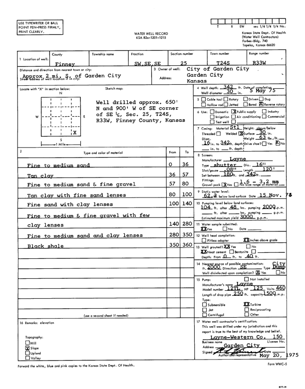
Specific Water Well Detail |
|
|
| Location Info | |||
| Owner: City of Garden City | Status: Constructed | ||
| Location: T24S, R33W, Sec. 25, SW SE SE | County: Finney | ||
| Directions: from Garden City, 2 mi S | |||
| Latitude: 37.9324354 | Longitude: -100.8864443 | Datum NAD 27 | |
| Latitude: 37.9324587 | Longitude: -100.8868849 | Datum NAD 83 | |
| Longitude and latitude calculated by Survey from township-range-section-quarter calls. Only good to within the quarter call accuracy. | |||
| View well on interactive map | |||
| General Info | ||
| Well Depth: 342 ft. | Elevation: ft. | |
| Static Water Level: 62.3 ft. | Est. Yield: 3000 gpm. | |
| Comp. Date: 05-May-1975 | Well Use: Public Water Supply | |
| DWR Applic. #: | Other ID: | |
| Links | |
| View info from Wizard Water Level Data base... | |
| View info from WIMAS Water Right Data base... | |
| Driller Info | ||
| Driller: Layne-Western | License #: 150 | |
| Scanned Form | View scan |
|
Chemical Sample Submitted?: Yes
Water Well disinfected?: | ||
| Ground water encountered: 0 ft. , 0 ft. , 0 ft. | ||
| Pump test data: Well water was 0 ft after 0 hours pumping 0 gpm | ||
| Casing Info | ||
| Casing Type:
Casing Joints: |
Diam: 0 in. to 0 ft
Diam: 0 in. to 0 ft Diam: 0 in. to 0 ft | |
| Casing height above land surface: in
Casing Weight: lbs/ft Wall thickness or gauge no.: | ||
| Screen and Perforation Info | ||
| Screen Type: | Screen Openings: | |
| Screen-perforated intervals | From: 180 ft to 342 ft
From: 0 ft to 0 ft From: 0 ft to 0 ft | |
| Gravel pack intervals | From: ft to ft | |
| Grout Info | ||
| Grout used: | From: 0 to 0 ft
From: 0 to 0 ft From: 0 to 0 ft | |
| Source of Possible Contamination | ||
| Source: | ||
| Direction from well: | Distance: 0 ft | |
| Lithologic Log
(Log data entered by KGS.) | ||
| From: 0 ft. to 36 ft. | fine to medium sand | |
| From: 36 ft. to 57 ft. | tan clay | |
| From: 57 ft. to 80 ft. | fine to medium sand and fine gravel | |
| From: 80 ft. to 100 ft. | tan clay with fine sand lenses | |
| From: 100 ft. to 140 ft. | fine sand with clay lenses | |
| From: 140 ft. to 280 ft. | fine to medium and fine gravel with few clay lenses | |
| From: 280 ft. to 350 ft. | fine to medium sand and clay lenses | |
| From: 350 ft. to 360 ft. | black shale | |