|
|
|
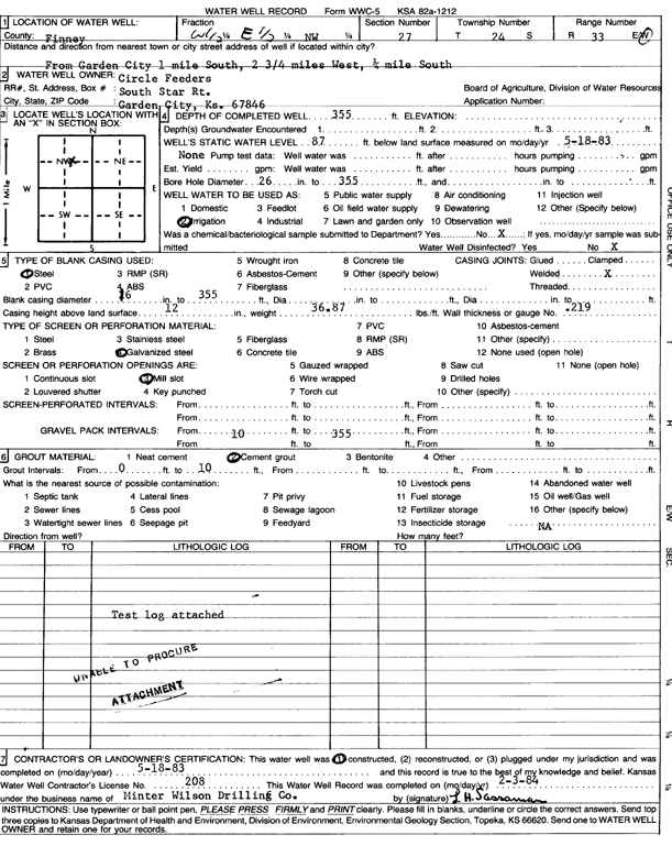
Specific Water Well Detail |
|
|
| Location Info | |||
| Owner: Circle Feeders | Status: Constructed | ||
| Location: T24S, R33W, Sec. 27, W2 E2 NW | County: Finney | ||
| Directions: from Garden City, 1 mi S, 2.75 mi W, and 0.25 mi S | |||
| Latitude: 37.9422328 | Longitude: -100.932169 | Datum NAD 27 | |
| Latitude: 37.9422565 | Longitude: -100.9326113 | Datum NAD 83 | |
| Longitude and latitude calculated by Survey from township-range-section-quarter calls. Only good to within the quarter call accuracy. | |||
| View well on interactive map | |||
| General Info | ||
| Well Depth: 355 ft. | Elevation: ft. | |
| Static Water Level: 87 ft. | Est. Yield: gpm. | |
| Comp. Date: 18-May-1983 | Well Use: Irrigation | |
| DWR Applic. #: | Other ID: | |
| Links | |
| No Wizard information available. | |
| View info from WIMAS Water Right Data base... | |
| Driller Info | ||
| Driller: MW Drilling | License #: 208 | |
| Scanned Form | View scan |
|
Chemical Sample Submitted?: No
Water Well disinfected?: | ||
| Ground water encountered: 0 ft. , 0 ft. , 0 ft. | ||
| Pump test data: Well water was 0 ft after 0 hours pumping 0 gpm | ||
| Casing Info | ||
| Casing Type:
Casing Joints: |
Diam: 0 in. to 0 ft
Diam: 0 in. to 0 ft Diam: 0 in. to 0 ft | |
| Casing height above land surface: in
Casing Weight: lbs/ft Wall thickness or gauge no.: | ||
| Screen and Perforation Info | ||
| Screen Type: | Screen Openings: | |
| Screen-perforated intervals | From: 0 ft to 0 ft
From: 0 ft to 0 ft From: 0 ft to 0 ft | |
| Gravel pack intervals | From: ft to ft | |
| Grout Info | ||
| Grout used: | From: 0 to 0 ft
From: 0 to 0 ft From: 0 to 0 ft | |
| Source of Possible Contamination | ||
| Source: | ||
| Direction from well: | Distance: 0 ft | |
| Lithologic Log
(log data not edited or checked by the KGS.) | ||
| From: 0 ft. to 10 ft. | Type: FINE SAND | |
| From: 10 ft. to 33 ft. | Type: GRAVEL | |
| From: 33 ft. to 109 ft. | Type: SANDY CLAY | |
| From: 109 ft. to 129 ft. | Type: SAND & GRAVEL | |
| From: 129 ft. to 140 ft. | Type: SANDY CLAY | |
| From: 140 ft. to 152 ft. | Type: SAND & GRAVEL | |
| From: 152 ft. to 168 ft. | Type: SANDY CLAY | |
| From: 168 ft. to 280 ft. | Type: SAND & GRAVEL | |
| From: 280 ft. to 296 ft. | Type: SANDY CLAY | |
| From: 296 ft. to 328 ft. | Type: SAND & GRAVEL | |
| From: 328 ft. to 350 ft. | Type: SANDY CLAY | |
| From: 350 ft. to 354 ft. | Type: SAND & GRAVEL | |
| From: 354 ft. to 356 ft. | Type: CLAY | |
| From: 356 ft. to 425 ft. | Type: SHALE | |