|
|
|
Specific Water Well Detail |
|
|
| Location Info | |||
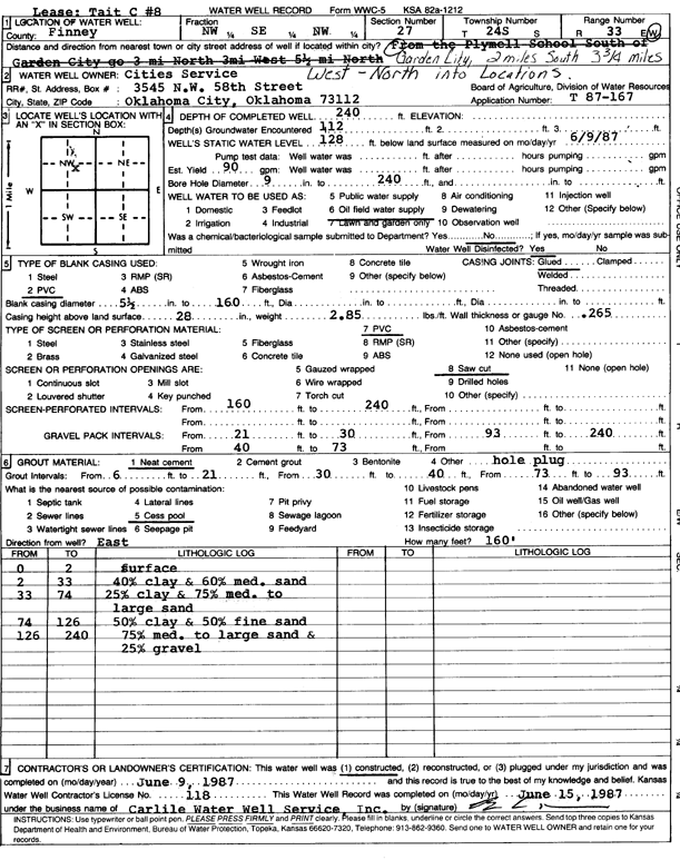
| Owner: Cities Service | Status: Constructed | ||
| Location: T24S, R33W, Sec. 27, NW SE NW | County: Finney | ||
| Directions: from Garden City, 2 mi S, 3.75 mi W, N into location | |||
| Latitude: 37.9413174 | Longitude: -100.9321489 | Datum NAD 27 | |
| Latitude: 37.9413411 | Longitude: -100.9325912 | Datum NAD 83 | |
| Longitude and latitude calculated by Survey from township-range-section-quarter calls. Only good to within the quarter call accuracy. | |||
| View well on interactive map | |||
| General Info | ||
| Well Depth: 240 ft. | Elevation: ft. | |
| Static Water Level: 128 ft. | Est. Yield: 90 gpm. | |
| Comp. Date: 09-Jun-1987 | Well Use: Oil Field Water Supply | |
| DWR Applic. #: T87-167 | Other ID: Tait C 8 | |
| Driller Info | ||
| Driller: Bernard E. Carlile Water Well Service, Inc. | License #: 118 | |
| Scanned Form | View scan |
|
Chemical Sample Submitted?: No
Water Well disinfected?: | ||
| Ground water encountered: 112 ft. , 0 ft. , 0 ft. | ||
| Pump test data: Well water was 0 ft after 0 hours pumping 0 gpm | ||
| Casing Info | ||
| Casing Type: PVC
Casing Joints: |
Diam: 5 in. to 160 ft
Diam: 0 in. to 0 ft Diam: 0 in. to 0 ft | |
| Casing height above land surface: in
Casing Weight: lbs/ft Wall thickness or gauge no.: | ||
| Screen and Perforation Info | ||
| Screen Type: PVC | Screen Openings: Saw cut | |
| Screen-perforated intervals | From: 160 ft to 240 ft
From: 0 ft to 0 ft From: 0 ft to 0 ft | |
| Gravel pack intervals | From: ft to ft | |
| Grout Info | ||
| Grout used: Neat cement | From: 6 to 21 ft
From: 30 to 40 ft From: 73 to 93 ft | |
| Source of Possible Contamination | ||
| Source: Cess pool | ||
| Direction from well: | Distance: 0 ft | |
| Lithologic Log
(Log data entered by KGS.) | ||
| From: 0 ft. to 2 ft. | surface | |
| From: 2 ft. to 33 ft. | 40% clay and 60% medium sand | |
| From: 33 ft. to 74 ft. | 25% clay and 75% med. to large sand | |
| From: 74 ft. to 126 ft. | 50% clay and 50% fine sand | |
| From: 126 ft. to 240 ft. | 75% med. to large sand and 25% gravel | |