|
|
|
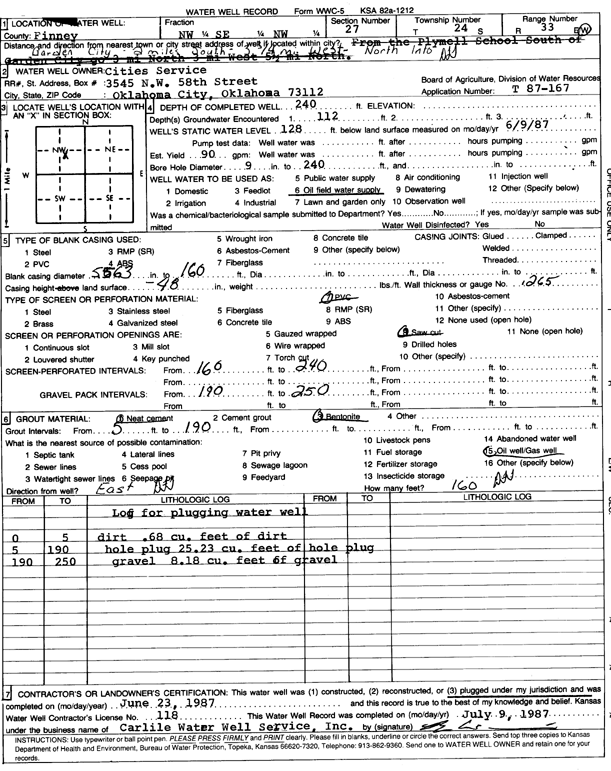
Specific Water Well Detail |
|
|
| Location Info | |||
| Owner: Cities Service | Status: Plugged | ||
| Location: T24S, R33W, Sec. 27, NW SE NW | County: Finney | ||
| Directions: from Garden City, 2 mi S, 3.75 mi W, and N into location | |||
| Latitude: 37.9413174 | Longitude: -100.9321489 | Datum NAD 27 | |
| Latitude: 37.9413411 | Longitude: -100.9325912 | Datum NAD 83 | |
| Longitude and latitude calculated by Survey from township-range-section-quarter calls. Only good to within the quarter call accuracy. | |||
| View well on interactive map | |||
| General Info | ||
| Well Depth: 240 ft. | Elevation: ft. | |
| Static Water Level: 128 ft. | Est. Yield: 90 gpm. | |
| Comp. Date: 23-Jun-1987 | Well Use: Oil Field Water Supply | |
| DWR Applic. #: T87-167 | Other ID: | |
| Driller Info | ||
| Driller: Bernard E. Carlile Water Well Service, Inc. | License #: 118 | |
| Scanned Form | View scan |
| Casing Info | ||
|
Casing Type:
Diam: 63 in. Casing height above land surface: in | ||
| Grout Info | ||
| Grout used: | From: 5 to 190 ft
From: 0 to 0 ft From: 0 to 0 ft | |
| Source of Possible Contamination | ||
| Source: Oil well/gas well | ||
| Direction from well: | Distance: 0 ft | |