|
|
|
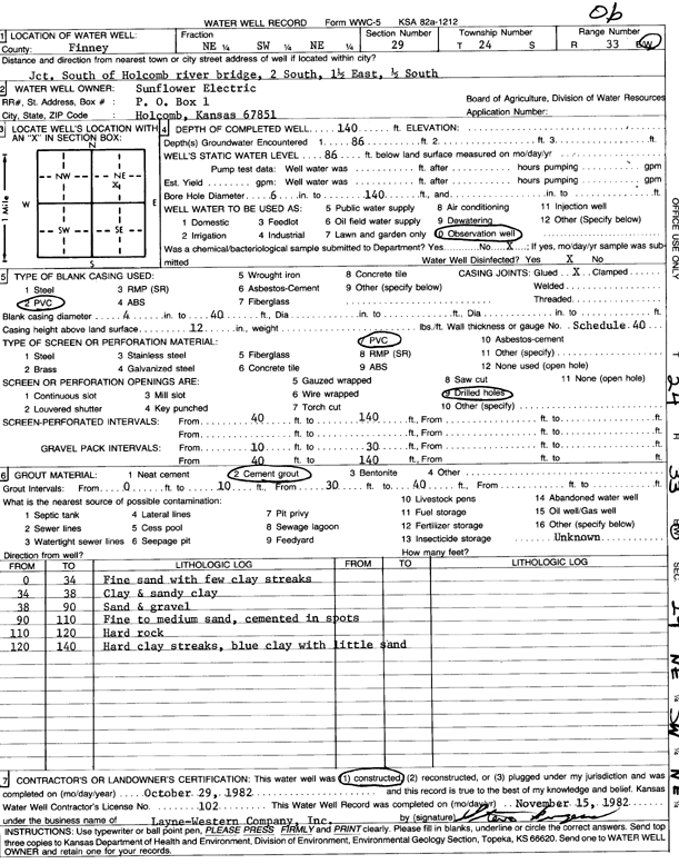
Specific Water Well Detail |
|
|
| Location Info | |||
| Owner: Sunflower Electric Power Corp. | Status: Constructed | ||
| Location: T24S, R33W, Sec. 29, NE SW NE | County: Finney | ||
| Directions: jct S of Holcomb river bridge: 2 mi S, 1.5 mi E, and 0.5 mi S | |||
| Latitude: 37.9412172 | Longitude: -100.962085 | Datum NAD 27 | |
| Latitude: 37.9412411 | Longitude: -100.9625285 | Datum NAD 83 | |
| Longitude and latitude calculated by Survey from township-range-section-quarter calls. Only good to within the quarter call accuracy. | |||
| View well on interactive map | |||
| General Info | ||
| Well Depth: 140 ft. | Elevation: ft. | |
| Static Water Level: 86 ft. | Est. Yield: gpm. | |
| Comp. Date: 29-Oct-1982 | Well Use: Monitoring well/observation/piezometer | |
| DWR Applic. #: | Other ID: | |
| Driller Info | ||
| Driller: Layne-Christensen Co. | License #: 102 | |
| Scanned Form | View scan |
|
Chemical Sample Submitted?: No
Water Well disinfected?: | ||
| Ground water encountered: 0 ft. , 0 ft. , 0 ft. | ||
| Pump test data: Well water was 0 ft after 0 hours pumping 0 gpm | ||
| Casing Info | ||
| Casing Type:
Casing Joints: |
Diam: 0 in. to 0 ft
Diam: 0 in. to 0 ft Diam: 0 in. to 0 ft | |
| Casing height above land surface: in
Casing Weight: lbs/ft Wall thickness or gauge no.: | ||
| Screen and Perforation Info | ||
| Screen Type: | Screen Openings: | |
| Screen-perforated intervals | From: 40 ft to 140 ft
From: 0 ft to 0 ft From: 0 ft to 0 ft | |
| Gravel pack intervals | From: ft to ft | |
| Grout Info | ||
| Grout used: | From: 0 to 0 ft
From: 0 to 0 ft From: 0 to 0 ft | |
| Source of Possible Contamination | ||
| Source: | ||
| Direction from well: | Distance: 0 ft | |
| Lithologic Log
(Log data entered by KGS.) | ||
| From: 0 ft. to 34 ft. | fine sand with few clay streaks | |
| From: 34 ft. to 38 ft. | clay and sandy clay | |
| From: 38 ft. to 90 ft. | sand and gravel | |
| From: 90 ft. to 110 ft. | fine to medium sand, cemented in spots | |
| From: 110 ft. to 120 ft. | hard rock | |
| From: 120 ft. to 140 ft. | hard clay streaks, blue clay with little sand | |