|
|
|
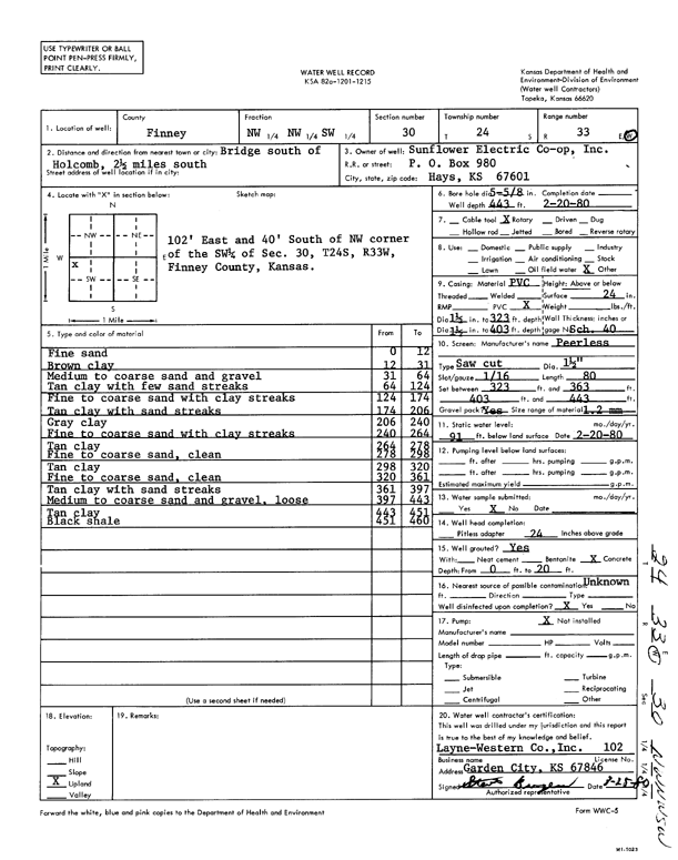
Specific Water Well Detail |
|
|
| Location Info | |||
| Owner: Sunflower Electric Power Corp. | Status: Constructed | ||
| Location: T24S, R33W, Sec. 30, NW NW SW | County: Finney | ||
| Directions: bridge S of Holcomb: 2.5 mi S | |||
| Latitude: 37.9375301 | Longitude: -100.9913265 | Datum NAD 27 | |
| Latitude: 37.9375543 | Longitude: -100.9917713 | Datum NAD 83 | |
| Longitude and latitude calculated by Survey from township-range-section-quarter calls. Only good to within the quarter call accuracy. | |||
| View well on interactive map | |||
| General Info | ||
| Well Depth: 443 ft. | Elevation: ft. | |
| Static Water Level: 91 ft. | Est. Yield: gpm. | |
| Comp. Date: 20-Feb-1980 | Well Use: (unstated)/abandoned | |
| DWR Applic. #: | Other ID: | |
| Links | |
| View info from Wizard Water Level Data base... | |
| No WIMAS information available. | |
| Driller Info | ||
| Driller: Layne-Christensen Co. | License #: 102 | |
| Scanned Form | View scan |
|
Chemical Sample Submitted?: No
Water Well disinfected?: | ||
| Ground water encountered: 0 ft. , 0 ft. , 0 ft. | ||
| Pump test data: Well water was 0 ft after 0 hours pumping 0 gpm | ||
| Casing Info | ||
| Casing Type:
Casing Joints: |
Diam: 0 in. to 0 ft
Diam: 0 in. to 0 ft Diam: 0 in. to 0 ft | |
| Casing height above land surface: in
Casing Weight: lbs/ft Wall thickness or gauge no.: | ||
| Screen and Perforation Info | ||
| Screen Type: | Screen Openings: | |
| Screen-perforated intervals | From: 323 ft to 363 ft
From: 403 ft to 443 ft From: 0 ft to 0 ft | |
| Gravel pack intervals | From: ft to ft | |
| Grout Info | ||
| Grout used: | From: 0 to 0 ft
From: 0 to 0 ft From: 0 to 0 ft | |
| Source of Possible Contamination | ||
| Source: | ||
| Direction from well: | Distance: 0 ft | |
| Lithologic Log
(Log data entered by KGS.) | ||
| From: 0 ft. to 12 ft. | fine sand | |
| From: 12 ft. to 31 ft. | brown clay | |
| From: 31 ft. to 64 ft. | medium to coarse sand and gravel | |
| From: 64 ft. to 124 ft. | tan clay with few sand streaks | |
| From: 124 ft. to 174 ft. | fine to coarse sand with clay streaks | |
| From: 174 ft. to 206 ft. | tan clay with sand streaks | |
| From: 206 ft. to 240 ft. | gray clay | |
| From: 240 ft. to 264 ft. | fine to coarse sand with clay streaks | |
| From: 264 ft. to 278 ft. | tan clay | |
| From: 278 ft. to 298 ft. | fine to coarse sand, clean | |
| From: 298 ft. to 320 ft. | tan clay | |
| From: 320 ft. to 361 ft. | fine to coarse sand, clean | |
| From: 361 ft. to 397 ft. | tan clay with sand streaks | |
| From: 397 ft. to 443 ft. | medium to coarse sand and gravel, loose | |
| From: 443 ft. to 451 ft. | tan clay | |
| From: 451 ft. to 460 ft. | black shale | |