|
|
|
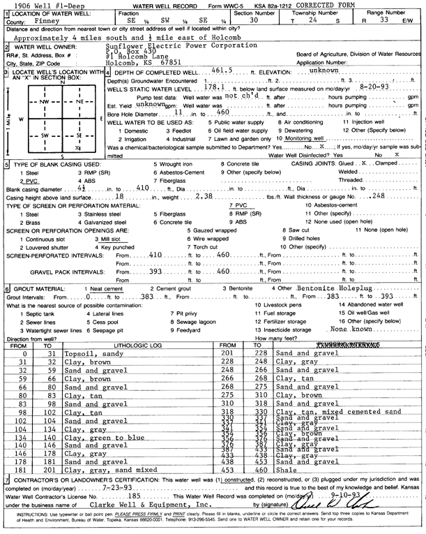
Specific Water Well Detail |
|
|
| Location Info | |||
| Owner: Sunflower Electric Power Corp. | Status: Constructed | ||
| Location: T24S, R33W, Sec. 30, SE SW SE | County: Finney | ||
| Directions: from Holcomb, 4 mi S and 0.5 mi E | |||
| Latitude: 37.9322264 | Longitude: -100.9801243 | Datum NAD 27 | |
| Latitude: 37.9322505 | Longitude: -100.9805686 | Datum NAD 83 | |
| Longitude and latitude calculated by Survey from township-range-section-quarter calls. Only good to within the quarter call accuracy. | |||
| View well on interactive map | |||
| General Info | ||
| Well Depth: 461 ft. | Elevation: ft. | |
| Static Water Level: 178.1 ft. | Est. Yield: gpm. | |
| Comp. Date: 23-Jul-1993 | Well Use: Monitoring well/observation/piezometer | |
| DWR Applic. #: | Other ID: | |
| Driller Info | ||
| Driller: Clarke Well and Equipment, Inc. | License #: 185 | |
| Scanned Form | View scan |
|
Chemical Sample Submitted?: No
Water Well disinfected?: | ||
| Ground water encountered: 0 ft. , 0 ft. , 0 ft. | ||
| Pump test data: Well water was 0 ft after 0 hours pumping 0 gpm | ||
| Casing Info | ||
| Casing Type: PVC
Casing Joints: |
Diam: 4 in. to 410 ft
Diam: 0 in. to 0 ft Diam: 0 in. to 0 ft | |
| Casing height above land surface: in
Casing Weight: lbs/ft Wall thickness or gauge no.: | ||
| Screen and Perforation Info | ||
| Screen Type: PVC | Screen Openings: Mill slot | |
| Screen-perforated intervals | From: 410 ft to 460 ft
From: 0 ft to 0 ft From: 0 ft to 0 ft | |
| Gravel pack intervals | From: ft to ft | |
| Grout Info | ||
| Grout used: Neat cement, | From: 0 to 383 ft
From: 383 to 393 ft From: 0 to 0 ft | |
| Source of Possible Contamination | ||
| Source: OTHER | ||
| Direction from well: | Distance: 0 ft | |
| Lithologic Log
(Log data entered by KGS.) | ||
| From: 0 ft. to 31 ft. | topsoil, sandy | |
| From: 31 ft. to 32 ft. | clay, brown | |
| From: 32 ft. to 59 ft. | sand and gravel | |
| From: 59 ft. to 66 ft. | clay, brown | |
| From: 66 ft. to 80 ft. | sand and gravel | |
| From: 80 ft. to 83 ft. | clay, tan | |
| From: 83 ft. to 98 ft. | sand and gravel | |
| From: 98 ft. to 102 ft. | clay, tan | |
| From: 102 ft. to 104 ft. | sand and gravel | |
| From: 104 ft. to 134 ft. | clay, gray | |
| From: 134 ft. to 140 ft. | clay, green to blue | |
| From: 140 ft. to 146 ft. | sand and gravel | |
| From: 146 ft. to 178 ft. | clay, gray | |
| From: 178 ft. to 181 ft. | sand and gravel | |
| From: 181 ft. to 201 ft. | clay, gray, sand mixed | |
| From: 201 ft. to 228 ft. | sand and gravel | |
| From: 228 ft. to 248 ft. | clay, gray | |
| From: 248 ft. to 266 ft. | sand and gravel | |
| From: 266 ft. to 268 ft. | clay, tan | |
| From: 268 ft. to 275 ft. | sand and gravel | |
| From: 275 ft. to 310 ft. | clay, brown | |
| From: 310 ft. to 318 ft. | sand and gravel | |
| From: 318 ft. to 330 ft. | clay, tan, mixed cemented sand | |
| From: 330 ft. to 337 ft. | sand and gravel | |
| From: 337 ft. to 341 ft. | clay, gray | |
| From: 341 ft. to 354 ft. | sand and gravel | |
| From: 354 ft. to 356 ft. | clay, brown | |
| From: 356 ft. to 376 ft. | sand and gravel | |
| From: 376 ft. to 387 ft. | clay, gray | |
| From: 387 ft. to 433 ft. | sand and gravel | |
| From: 433 ft. to 438 ft. | clay, gray | |
| From: 438 ft. to 453 ft. | sand and gravel | |
| From: 453 ft. to 460 ft. | shale | |