|
|
|
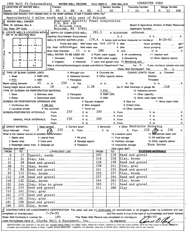
Specific Water Well Detail |
|
|
| Location Info | |||
| Owner: Sunflower Electric Power Corp. | Status: Constructed | ||
| Location: T24S, R33W, Sec. 30, SE SW SE | County: Finney | ||
| Directions: from Holcomb, 4 mi S and 0.5 mi E | |||
| Latitude: 37.9322264 | Longitude: -100.9801243 | Datum NAD 27 | |
| Latitude: 37.9322505 | Longitude: -100.9805686 | Datum NAD 83 | |
| Longitude and latitude calculated by Survey from township-range-section-quarter calls. Only good to within the quarter call accuracy. | |||
| View well on interactive map | |||
| General Info | ||
| Well Depth: 281 ft. | Elevation: ft. | |
| Static Water Level: 179.4 ft. | Est. Yield: gpm. | |
| Comp. Date: 29-Jul-1993 | Well Use: Monitoring well/observation/piezometer | |
| DWR Applic. #: | Other ID: | |
| Driller Info | ||
| Driller: Clarke Well and Equipment, Inc. | License #: 185 | |
| Scanned Form | View scan |
|
Chemical Sample Submitted?: No
Water Well disinfected?: | ||
| Ground water encountered: 0 ft. , 0 ft. , 0 ft. | ||
| Pump test data: Well water was 0 ft after 0 hours pumping 0 gpm | ||
| Casing Info | ||
| Casing Type: PVC
Casing Joints: |
Diam: 4 in. to 250 ft
Diam: 0 in. to 0 ft Diam: 0 in. to 0 ft | |
| Casing height above land surface: in
Casing Weight: lbs/ft Wall thickness or gauge no.: | ||
| Screen and Perforation Info | ||
| Screen Type: PVC | Screen Openings: Mill slot | |
| Screen-perforated intervals | From: 250 ft to 280 ft
From: 0 ft to 0 ft From: 0 ft to 0 ft | |
| Gravel pack intervals | From: ft to ft | |
| Grout Info | ||
| Grout used: Neat cement, | From: 0 to 220 ft
From: 220 to 230 ft From: 0 to 0 ft | |
| Source of Possible Contamination | ||
| Source: OTHER | ||
| Direction from well: | Distance: 0 ft | |
| Lithologic Log
(Log data entered by KGS.) | ||
| From: 0 ft. to 17 ft. | topsoil, sandy | |
| From: 17 ft. to 31 ft. | clay, tan | |
| From: 31 ft. to 58 ft. | sand and gravel | |
| From: 58 ft. to 71 ft. | clay, brown | |
| From: 71 ft. to 93 ft. | sand and gravel | |
| From: 93 ft. to 112 ft. | clay, brown | |
| From: 112 ft. to 118 ft. | sand and gravel | |
| From: 118 ft. to 132 ft. | clay, brown | |
| From: 132 ft. to 144 ft. | clay, blue to green | |
| From: 144 ft. to 153 ft. | sand and gravel | |
| From: 153 ft. to 162 ft. | clay, gray | |
| From: 162 ft. to 173 ft. | sand and gravel | |
| From: 173 ft. to 181 ft. | clay, gray | |
| From: 181 ft. to 198 ft. | sand and gravel | |
| From: 198 ft. to 203 ft. | clay, brown | |
| From: 203 ft. to 218 ft. | sand and gravel | |
| From: 218 ft. to 228 ft. | clay, brown | |
| From: 228 ft. to 238 ft. | sand and gravel | |
| From: 238 ft. to 241 ft. | clay, gray | |
| From: 241 ft. to 255 ft. | sand and gravel | |
| From: 255 ft. to 257 ft. | clay, brown | |
| From: 257 ft. to 264 ft. | sand and gravel | |
| From: 264 ft. to 265 ft. | clay, brown | |
| From: 265 ft. to 271 ft. | sand and gravel | |
| From: 271 ft. to 280 ft. | clay | |