|
|
|
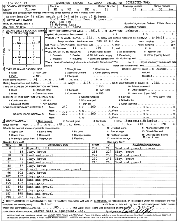
Specific Water Well Detail |
|
|
| Location Info | |||
| Owner: Sunflower Electric Power Corp. | Status: Constructed | ||
| Location: T24S, R33W, Sec. 31, SE NE NE | County: Finney | ||
| Directions: from Holcomb, 4.25 mi S and 0.75 mi E | |||
| Latitude: 37.9286332 | Longitude: -100.9756374 | Datum NAD 27 | |
| Latitude: 37.9286571 | Longitude: -100.9760815 | Datum NAD 83 | |
| Longitude and latitude calculated by Survey from township-range-section-quarter calls. Only good to within the quarter call accuracy. | |||
| View well on interactive map | |||
| General Info | ||
| Well Depth: 261 ft. | Elevation: ft. | |
| Static Water Level: 171 ft. | Est. Yield: gpm. | |
| Comp. Date: 11-Aug-1993 | Well Use: Monitoring well/observation/piezometer | |
| DWR Applic. #: | Other ID: | |
| Driller Info | ||
| Driller: Clarke Well and Equipment, Inc. | License #: 185 | |
| Scanned Form | View scan |
|
Chemical Sample Submitted?: No
Water Well disinfected?: | ||
| Ground water encountered: 0 ft. , 0 ft. , 0 ft. | ||
| Pump test data: Well water was 0 ft after 0 hours pumping 0 gpm | ||
| Casing Info | ||
| Casing Type: PVC
Casing Joints: |
Diam: 4 in. to 240 ft
Diam: 0 in. to 0 ft Diam: 0 in. to 0 ft | |
| Casing height above land surface: in
Casing Weight: lbs/ft Wall thickness or gauge no.: | ||
| Screen and Perforation Info | ||
| Screen Type: PVC | Screen Openings: Mill slot | |
| Screen-perforated intervals | From: 240 ft to 260 ft
From: 0 ft to 0 ft From: 0 ft to 0 ft | |
| Gravel pack intervals | From: ft to ft | |
| Grout Info | ||
| Grout used: Neat cement, | From: 210 to 220 ft
From: 0 to 0 ft From: 0 to 0 ft | |
| Source of Possible Contamination | ||
| Source: OTHER | ||
| Direction from well: | Distance: 0 ft | |
| Lithologic Log
(Log data entered by KGS.) | ||
| From: 0 ft. to 4 ft. | topsoil, fill | |
| From: 4 ft. to 18 ft. | clay, brown | |
| From: 18 ft. to 39 ft. | sand and gravel | |
| From: 39 ft. to 51 ft. | clay, brown | |
| From: 51 ft. to 85 ft. | sand and gravel | |
| From: 85 ft. to 87 ft. | clay, brown | |
| From: 87 ft. to 96 ft. | gravel, very coarse, pea gravel | |
| From: 96 ft. to 102 ft. | clay, brown | |
| From: 102 ft. to 132 ft. | clay, gray | |
| From: 132 ft. to 153 ft. | sand and gravel | |
| From: 153 ft. to 157 ft. | clay, gray | |
| From: 157 ft. to 163 ft. | sand and gravel | |
| From: 163 ft. to 187 ft. | clay, gray | |
| From: 187 ft. to 198 ft. | sand and gravel | |
| From: 198 ft. to 207 ft. | clay, brown | |
| From: 207 ft. to 218 ft. | sand and gravel, coarse | |
| From: 218 ft. to 224 ft. | clay, brown | |
| From: 224 ft. to 230 ft. | sand and gravel | |
| From: 230 ft. to 243 ft. | clay, brown | |
| From: 243 ft. to 260 ft. | sand and gravel | |