|
|
|
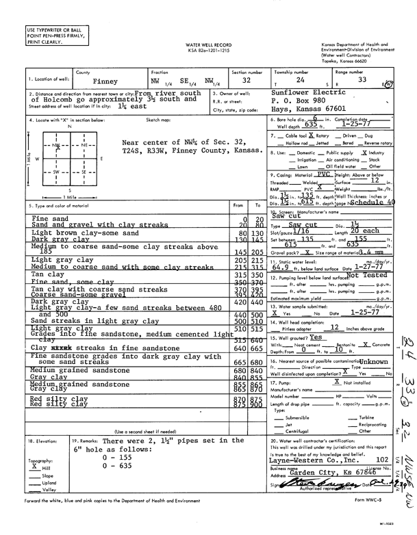
Specific Water Well Detail |
|
|
| Location Info | |||
| Owner: Sunflower Electric Power Corp. | Status: Constructed | ||
| Location: T24S, R33W, Sec. 32, NW SE NW | County: Finney | ||
| Directions: from river S of Holcomb: 3.5 mi S and 1.25 mi E | |||
| Latitude: 37.9267875 | Longitude: -100.9688556 | Datum NAD 27 | |
| Latitude: 37.9268114 | Longitude: -100.9692995 | Datum NAD 83 | |
| Longitude and latitude calculated by Survey from township-range-section-quarter calls. Only good to within the quarter call accuracy. | |||
| View well on interactive map | |||
| General Info | ||
| Well Depth: 635 ft. | Elevation: ft. | |
| Static Water Level: 64.9 ft. | Est. Yield: gpm. | |
| Comp. Date: 25-Jan-1977 | Well Use: Industrial | |
| DWR Applic. #: | Other ID: | |
| Links | |
| View info from Wizard Water Level Data base... | |
| No WIMAS information available. | |
| Driller Info | ||
| Driller: Layne-Christensen Co. | License #: 102 | |
| Scanned Form | View scan |
|
Chemical Sample Submitted?: Yes
Water Well disinfected?: | ||
| Ground water encountered: 0 ft. , 0 ft. , 0 ft. | ||
| Pump test data: Well water was 0 ft after 0 hours pumping 0 gpm | ||
| Casing Info | ||
| Casing Type:
Casing Joints: |
Diam: 0 in. to 0 ft
Diam: 0 in. to 0 ft Diam: 0 in. to 0 ft | |
| Casing height above land surface: in
Casing Weight: lbs/ft Wall thickness or gauge no.: | ||
| Screen and Perforation Info | ||
| Screen Type: | Screen Openings: | |
| Screen-perforated intervals | From: 135 ft to 155 ft
From: 615 ft to 635 ft From: 0 ft to 0 ft | |
| Gravel pack intervals | From: ft to ft | |
| Grout Info | ||
| Grout used: | From: 0 to 0 ft
From: 0 to 0 ft From: 0 to 0 ft | |
| Source of Possible Contamination | ||
| Source: | ||
| Direction from well: | Distance: 0 ft | |
| Lithologic Log
(Log data entered by KGS.) | ||
| From: 0 ft. to 20 ft. | fine sand | |
| From: 20 ft. to 80 ft. | sand and gravel with clay streaks | |
| From: 80 ft. to 130 ft. | light brown clay - some sand | |
| From: 130 ft. to 145 ft. | dark gray clay | |
| From: 145 ft. to 205 ft. | medium to coarse sand - some clay streaks above 185 | |
| From: 205 ft. to 215 ft. | light gray clay | |
| From: 215 ft. to 315 ft. | medium to coarse sand with some clay streaks | |
| From: 315 ft. to 350 ft. | tan clay | |
| From: 350 ft. to 370 ft. | fine sand, some clay | |
| From: 370 ft. to 395 ft. | tan clay with coarse sand streaks | |
| From: 395 ft. to 420 ft. | coarse sand - some gravel | |
| From: 420 ft. to 440 ft. | dark gray clay | |
| From: 440 ft. to 500 ft. | light gray clay - a few sand streaks between 480 and 500 | |
| From: 500 ft. to 510 ft. | sand streaks in light gray clay | |
| From: 510 ft. to 515 ft. | light gray clay | |
| From: 515 ft. to 640 ft. | grades into fine sandstone, medium cemented light clay | |
| From: 640 ft. to 665 ft. | clay streaks in fine sandstone | |
| From: 665 ft. to 680 ft. | fine sandstone grades into dark gray clay with some sand streaks | |
| From: 680 ft. to 840 ft. | medium grained sandstone | |
| From: 840 ft. to 855 ft. | gray clay | |
| From: 855 ft. to 865 ft. | medium grained sandstone | |
| From: 865 ft. to 870 ft. | gray clay | |
| From: 870 ft. to 875 ft. | red silty clay | |
| From: 875 ft. to 900 ft. | red silty clay | |