|
|
|
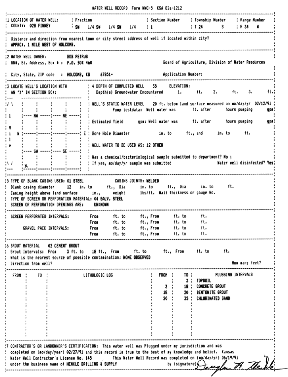
Specific Water Well Detail |
|
|
| Location Info | |||
| Owner: Petrus, Bob | Status: Plugged | ||
| Location: T24S, R34W, Sec. 1, SW SW SW | County: Finney | ||
| Directions: from Holcomb, 1 mi W | |||
| Latitude: 37.9899352 | Longitude: -101.0099704 | Datum NAD 27 | |
| Latitude: 37.9899594 | Longitude: -101.010415 | Datum NAD 83 | |
| Longitude and latitude calculated by Survey from township-range-section-quarter calls. Only good to within the quarter call accuracy. | |||
| View well on interactive map | |||
| General Info | ||
| Well Depth: 35 ft. | Elevation: ft. | |
| Static Water Level: 20 ft. | Est. Yield: gpm. | |
| Comp. Date: 27-Feb-1991 | Well Use: (unstated)/abandoned | |
| DWR Applic. #: | Other ID: | |
| Driller Info | ||
| Driller: Henkle Drilling & Supply Co. Inc. | License #: 145 | |
| Scanned Form | View scan |
| Casing Info | ||
|
Casing Type: Steel
Diam: 12 in. Casing height above land surface: in | ||
| Grout Info | ||
| Grout used: Cement grout | From: 3 to 18 ft
From: 0 to 0 ft From: 0 to 0 ft | |
| Source of Possible Contamination | ||
| Source: OTHER | ||
| Direction from well: | Distance: 0 ft | |