|
|
|
Specific Water Well Detail |
|
|
| Location Info | |||
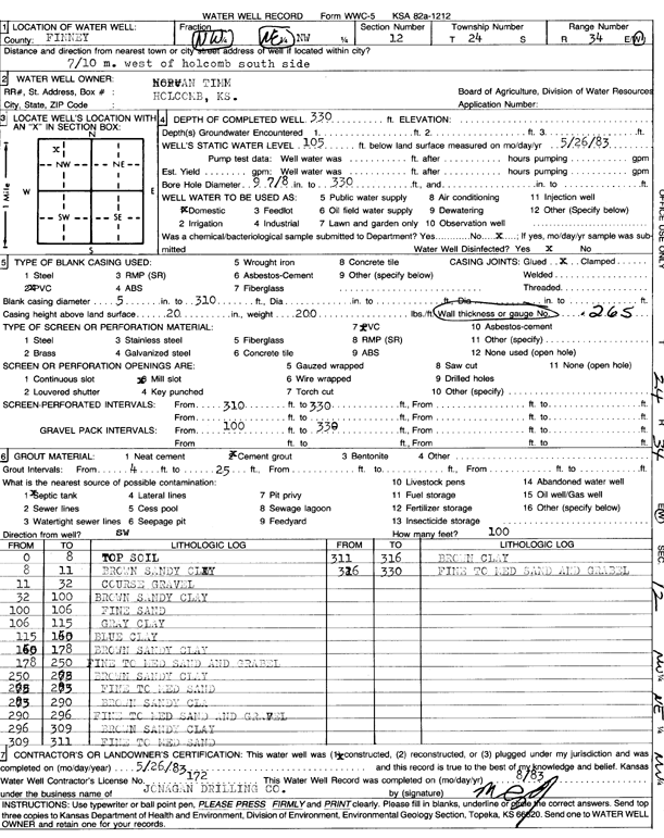
| Owner: Timm, Norman | Status: Constructed | ||
| Location: T24S, R34W, Sec. 12, NW NE NW | County: Finney | ||
| Directions: from Holcomb, 0.7 mi W, S side | |||
| Latitude: 37.9881454 | Longitude: -101.0053719 | Datum NAD 27 | |
| Latitude: 37.9881696 | Longitude: -101.0058165 | Datum NAD 83 | |
| Longitude and latitude calculated by Survey from township-range-section-quarter calls. Only good to within the quarter call accuracy. | |||
| View well on interactive map | |||
| General Info | ||
| Well Depth: 330 ft. | Elevation: ft. | |
| Static Water Level: 105 ft. | Est. Yield: gpm. | |
| Comp. Date: 26-May-1983 | Well Use: Domestic | |
| DWR Applic. #: | Other ID: | |
| Driller Info | ||
| Driller: Jonagan Water Well Service LLC | License #: 172 | |
| Scanned Form | View scan |
|
Chemical Sample Submitted?: No
Water Well disinfected?: | ||
| Ground water encountered: 0 ft. , 0 ft. , 0 ft. | ||
| Pump test data: Well water was 0 ft after 0 hours pumping 0 gpm | ||
| Casing Info | ||
| Casing Type:
Casing Joints: |
Diam: 0 in. to 0 ft
Diam: 0 in. to 0 ft Diam: 0 in. to 0 ft | |
| Casing height above land surface: in
Casing Weight: lbs/ft Wall thickness or gauge no.: | ||
| Screen and Perforation Info | ||
| Screen Type: | Screen Openings: | |
| Screen-perforated intervals | From: 310 ft to 330 ft
From: 0 ft to 0 ft From: 0 ft to 0 ft | |
| Gravel pack intervals | From: ft to ft | |
| Grout Info | ||
| Grout used: | From: 0 to 0 ft
From: 0 to 0 ft From: 0 to 0 ft | |
| Source of Possible Contamination | ||
| Source: | ||
| Direction from well: | Distance: 0 ft | |
| Lithologic Log
(Log data entered by KGS.) | ||
| From: 0 ft. to 8 ft. | top soil | |
| From: 8 ft. to 11 ft. | brown sandy clay | |
| From: 11 ft. to 32 ft. | coarse gravel | |
| From: 32 ft. to 100 ft. | brown sandy clay | |
| From: 100 ft. to 106 ft. | fine sand | |
| From: 106 ft. to 115 ft. | gray clay | |
| From: 115 ft. to 160 ft. | blue clay | |
| From: 160 ft. to 178 ft. | brown sandy clay | |
| From: 178 ft. to 250 ft. | fine to medium sand and gravel | |
| From: 250 ft. to 275 ft. | brown sandy clay | |
| From: 275 ft. to 285 ft. | fine to medium sand | |
| From: 285 ft. to 290 ft. | brown sandy clay | |
| From: 290 ft. to 296 ft. | fine to medium sand and gravel | |
| From: 296 ft. to 309 ft. | brown sandy clay | |
| From: 309 ft. to 311 ft. | fine to medium sand | |
| From: 311 ft. to 316 ft. | brown clay | |
| From: 316 ft. to 330 ft. | fine to medium sand and gravel | |