|
|
|
Specific Water Well Detail |
|
|
| Location Info | |||
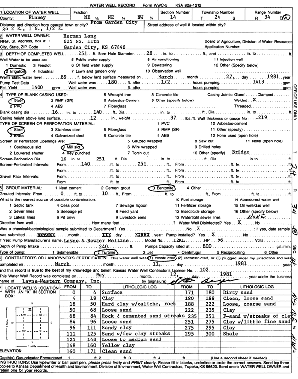
| Owner: Lang, Herman | Status: Constructed | ||
| Location: T24S, R34W, Sec. 14, NE NE NW | County: Finney | ||
| Directions: from Garden City: 2 mi E, 1 mi N, and 0.5 mi E | |||
| Latitude: 37.9736018 | Longitude: -101.0212959 | Datum NAD 27 | |
| Latitude: 37.9736257 | Longitude: -101.0217409 | Datum NAD 83 | |
| Longitude and latitude calculated by Survey from township-range-section-quarter calls. Only good to within the quarter call accuracy. | |||
| View well on interactive map | |||
| General Info | ||
| Well Depth: 251 ft. | Elevation: ft. | |
| Static Water Level: 89 ft. | Est. Yield: 1400 gpm. | |
| Comp. Date: 11-Mar-1981 | Well Use: Irrigation | |
| DWR Applic. #: | Other ID: | |
| Links | |
| No Wizard information available. | |
| View info from WIMAS Water Right Data base... | |
| Driller Info | ||
| Driller: Layne-Christensen Co. | License #: 102 | |
| Scanned Form | View scan |
|
Chemical Sample Submitted?: No
Water Well disinfected?: | ||
| Ground water encountered: 0 ft. , 0 ft. , 0 ft. | ||
| Pump test data: Well water was 0 ft after 0 hours pumping 0 gpm | ||
| Casing Info | ||
| Casing Type:
Casing Joints: |
Diam: 0 in. to 0 ft
Diam: 0 in. to 0 ft Diam: 0 in. to 0 ft | |
| Casing height above land surface: in
Casing Weight: lbs/ft Wall thickness or gauge no.: | ||
| Screen and Perforation Info | ||
| Screen Type: | Screen Openings: | |
| Screen-perforated intervals | From: 140 ft to 251 ft
From: 0 ft to 0 ft From: 0 ft to 0 ft | |
| Gravel pack intervals | From: ft to ft | |
| Grout Info | ||
| Grout used: | From: 0 to 0 ft
From: 0 to 0 ft From: 0 to 0 ft | |
| Source of Possible Contamination | ||
| Source: | ||
| Direction from well: | Distance: 0 ft | |
| Lithologic Log
(Log data entered by KGS.) | ||
| From: 0 ft. to 4 ft. | surface | |
| From: 4 ft. to 18 ft. | clay | |
| From: 18 ft. to 50 ft. | hard clay with caliche, rock | |
| From: 50 ft. to 68 ft. | loose sand | |
| From: 68 ft. to 84 ft. | rock and cemented sand streaks | |
| From: 84 ft. to 96 ft. | loose sand | |
| From: 96 ft. to 111 ft. | sandy clay | |
| From: 111 ft. to 125 ft. | sand with few clay streaks | |
| From: 125 ft. to 148 ft. | loose to medium sand | |
| From: 148 ft. to 160 ft. | yellow clay | |
| From: 160 ft. to 171 ft. | clean sand | |
| From: 171 ft. to 180 ft. | dirty sand | |
| From: 180 ft. to 188 ft. | clean, loose sand | |
| From: 188 ft. to 222 ft. | loose, coarse sand | |
| From: 222 ft. to 235 ft. | clay | |
| From: 235 ft. to 251 ft. | f-sand with streaks of clay | |
| From: 251 ft. to 275 ft. | clay with little fine sand | |
| From: 275 ft. to 295 ft. | clay | |
| From: 295 ft. to 300 ft. | shale | |