|
|
|
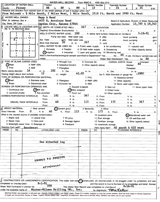
Specific Water Well Detail |
|
|
| Location Info | |||
| Owner: Rapp and Reed | Status: Constructed | ||
| Location: T24S, R34W, Sec. 15, NE SW NW | County: Finney | ||
| Directions: from Holcomb: 0.5 mi S, 2 mi W, 1 mi S, 3518 feet N, and 3990 feet W | |||
| Latitude: 37.9698629 | Longitude: -101.0442902 | Datum NAD 27 | |
| Latitude: 37.9698865 | Longitude: -101.0447354 | Datum NAD 83 | |
| Longitude and latitude calculated by Survey from township-range-section-quarter calls. Only good to within the quarter call accuracy. | |||
| View well on interactive map | |||
| General Info | ||
| Well Depth: 367 ft. | Elevation: ft. | |
| Static Water Level: 100 ft. | Est. Yield: gpm. | |
| Comp. Date: 01-Aug-1991 | Well Use: Irrigation | |
| DWR Applic. #: 13785 | Other ID: | |
| Links | |
| No Wizard information available. | |
| View info from WIMAS Water Right Data base... | |
| Driller Info | ||
| Driller: Minter-Wilson Drlg. Co., Inc. | License #: 208 | |
| Scanned Form | View scan |
|
Chemical Sample Submitted?: No
Water Well disinfected?: | ||
| Ground water encountered: 0 ft. , 0 ft. , 0 ft. | ||
| Pump test data: Well water was 0 ft after 0 hours pumping 0 gpm | ||
| Casing Info | ||
| Casing Type: Steel
Casing Joints: |
Diam: 16 in. to 182 ft
Diam: 0 in. to 0 ft Diam: 0 in. to 0 ft | |
| Casing height above land surface: in
Casing Weight: lbs/ft Wall thickness or gauge no.: | ||
| Screen and Perforation Info | ||
| Screen Type: Steel | Screen Openings: Wire wrapped | |
| Screen-perforated intervals | From: 182 ft to 367 ft
From: 0 ft to 0 ft From: 0 ft to 0 ft | |
| Gravel pack intervals | From: ft to ft | |
| Grout Info | ||
| Grout used: Cement grout | From: 0 to 40 ft
From: 115 to 175 ft From: 0 to 0 ft | |
| Source of Possible Contamination | ||
| Source: Abandoned water well | ||
| Direction from well: | Distance: 0 ft | |
| Lithologic Log
(log data not edited or checked by the KGS.) | ||
| From: 0 ft. to 2 ft. | Type: CLAY | |
| From: 2 ft. to 8 ft. | Type: SAND & GRAVEL | |
| From: 8 ft. to 41 ft. | Type: MEDIUM GRAVEL | |
| From: 41 ft. to 138 ft. | Type: CLAY | |
| From: 138 ft. to 145 ft. | Type: FINE SAND | |
| From: 145 ft. to 182 ft. | Type: SANDY CLAY | |
| From: 182 ft. to 202 ft. | Type: SAND & GRAVEL | |
| From: 202 ft. to 221 ft. | Type: SANDY CLAY | |
| From: 221 ft. to 226 ft. | Type: FINE SAND | |
| From: 226 ft. to 233 ft. | Type: SANDY CLAY | |
| From: 233 ft. to 241 ft. | Type: SAND & GRAVEL | |
| From: 241 ft. to 253 ft. | Type: SANDY CLAY | |
| From: 253 ft. to 322 ft. | Type: SAND & GRAVEL | |
| From: 322 ft. to 324 ft. | Type: CLAY | |
| From: 324 ft. to 331 ft. | Type: SAND & GRAVEL | |
| From: 331 ft. to 341 ft. | Type: CLAY | |
| From: 341 ft. to 359 ft. | Type: SAND & GRAVEL | |
| From: 359 ft. to 368 ft. | Type: CLAY | |
| From: 368 ft. to 380 ft. | Type: SHALE | |