|
|
|
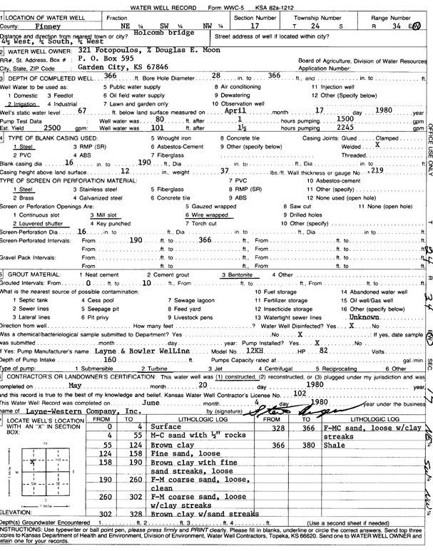
Specific Water Well Detail |
|
|
| Location Info | |||
| Owner: 321 Fotopoulos | Status: Constructed | ||
| Location: T24S, R34W, Sec. 17, NE SW NW | County: Finney | ||
| Directions: from Holcomb bridge, 4.5 mi W, 0.25 S, and 0.25 mi W | |||
| Latitude: 37.9696599 | Longitude: -101.0807271 | Datum NAD 27 | |
| Latitude: 37.9696827 | Longitude: -101.0811726 | Datum NAD 83 | |
| Longitude and latitude calculated by Survey from township-range-section-quarter calls. Only good to within the quarter call accuracy. | |||
| View well on interactive map | |||
| General Info | ||
| Well Depth: 366 ft. | Elevation: ft. | |
| Static Water Level: 67 ft. | Est. Yield: 2500 gpm. | |
| Comp. Date: 20-May-1980 | Well Use: Irrigation | |
| DWR Applic. #: | Other ID: | |
| Links | |
| No Wizard information available. | |
| View info from WIMAS Water Right Data base... | |
| Driller Info | ||
| Driller: Layne-Christensen Co. | License #: 102 | |
| Scanned Form | View scan |
|
Chemical Sample Submitted?: No
Water Well disinfected?: | ||
| Ground water encountered: 0 ft. , 0 ft. , 0 ft. | ||
| Pump test data: Well water was 0 ft after 0 hours pumping 0 gpm | ||
| Casing Info | ||
| Casing Type:
Casing Joints: |
Diam: 0 in. to 0 ft
Diam: 0 in. to 0 ft Diam: 0 in. to 0 ft | |
| Casing height above land surface: in
Casing Weight: lbs/ft Wall thickness or gauge no.: | ||
| Screen and Perforation Info | ||
| Screen Type: | Screen Openings: | |
| Screen-perforated intervals | From: 190 ft to 366 ft
From: 0 ft to 0 ft From: 0 ft to 0 ft | |
| Gravel pack intervals | From: ft to ft | |
| Grout Info | ||
| Grout used: | From: 0 to 0 ft
From: 0 to 0 ft From: 0 to 0 ft | |
| Source of Possible Contamination | ||
| Source: | ||
| Direction from well: | Distance: 0 ft | |
| Lithologic Log
(Log data entered by KGS.) | ||
| From: 0 ft. to 4 ft. | surface | |
| From: 4 ft. to 55 ft. | medium-coarse sand with 1/2-inch rocks | |
| From: 55 ft. to 124 ft. | brown clay | |
| From: 124 ft. to 158 ft. | fine sand, loose | |
| From: 158 ft. to 190 ft. | brown clay with fine sand streaks, loose | |
| From: 190 ft. to 260 ft. | f-m coarse sand, loose, clean | |
| From: 260 ft. to 302 ft. | f-m coarse sand, loose with clay streaks | |
| From: 302 ft. to 328 ft. | brown clay with sand streaks | |
| From: 328 ft. to 366 ft. | f-mc sand, loose with clay streaks | |
| From: 366 ft. to 380 ft. | shale | |