|
|
|
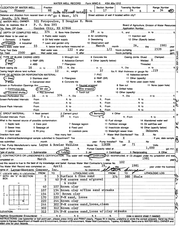
Specific Water Well Detail |
|
|
| Location Info | |||
| Owner: 321 Fotopoulos | Status: Constructed | ||
| Location: T24S, R34W, Sec. 17, NE SW SE | County: Finney | ||
| Directions: from Holcomb bridge: 4 mi W, 0.75 mi S, and 0.25 mi W | |||
| Latitude: 37.9624729 | Longitude: -101.0716556 | Datum NAD 27 | |
| Latitude: 37.9624958 | Longitude: -101.0721012 | Datum NAD 83 | |
| Longitude and latitude calculated by Survey from township-range-section-quarter calls. Only good to within the quarter call accuracy. | |||
| View well on interactive map | |||
| General Info | ||
| Well Depth: 374 ft. | Elevation: ft. | |
| Static Water Level: 55 ft. | Est. Yield: 2500 gpm. | |
| Comp. Date: 04-Mar-1981 | Well Use: Irrigation | |
| DWR Applic. #: | Other ID: | |
| Links | |
| View info from Wizard Water Level Data base... | |
| View info from WIMAS Water Right Data base... | |
| Driller Info | ||
| Driller: Layne-Christensen Co. | License #: 102 | |
| Scanned Form | View scan |
|
Chemical Sample Submitted?: No
Water Well disinfected?: Yes | ||
| Ground water encountered: 0 ft. , 0 ft. , 0 ft. | ||
| Pump test data: Well water was 122 ft after .5 hours pumping 2539 gpm | ||
| Bore hole diameter: 28 inches to ft | ||
| Casing Info | ||
| Casing Type: Steel
Casing Joints: Welded |
Diam: 16 in. to 170 ft
Diam: 0 in. to 0 ft Diam: 0 in. to 0 ft | |
| Casing height above land surface: 12 in
Casing Weight: 37 lbs/ft Wall thickness or gauge no.: .219 | ||
| Screen and Perforation Info | ||
| Screen Type: Steel | Screen Openings: Mill slot | |
| Screen-perforated intervals | From: 0 ft to 0 ft
From: 0 ft to 0 ft From: 0 ft to 0 ft | |
| Gravel pack intervals | From: ft to ft | |
| Grout Info | ||
| Grout used: Bentonite | From: 0 to 10 ft
From: 0 to 0 ft From: 0 to 0 ft | |
| Source of Possible Contamination | ||
| Source: Unknown | ||
| Direction from well: | Distance: 0 ft | |
| Lithologic Log
(Log data entered by KGS.) | ||
| From: 0 ft. to 5 ft. | surface and fine sand | |
| From: 5 ft. to 40 ft. | f-m coarse sand with gravel and rocks | |
| From: 40 ft. to 107 ft. | brown clay | |
| From: 107 ft. to 154 ft. | brown clay with fine sand streaks | |
| From: 154 ft. to 170 ft. | brown clay | |
| From: 170 ft. to 220 ft. | f-m sand, loose | |
| From: 220 ft. to 244 ft. | brown clay | |
| From: 244 ft. to 302 ft. | f-m coarse sand, loose, clean | |
| From: 302 ft. to 312 ft. | brown clay | |
| From: 312 ft. to 374 ft. | f-m coarse sand, loose with clay streaks | |
| From: 374 ft. to 380 ft. | shale | |