|
|
|
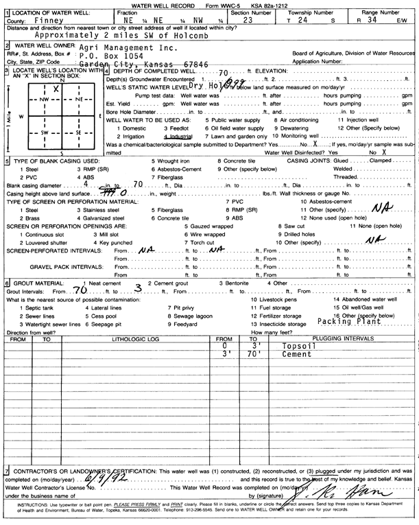
Specific Water Well Detail |
|
|
| Location Info | |||
| Owner: Agri Management, Inc. | Status: Plugged | ||
| Location: T24S, R34W, Sec. 23, NE NE NW | County: Finney | ||
| Directions: from Holcomb, 2 mi SW | |||
| Latitude: 37.9591438 | Longitude: -101.0211798 | Datum NAD 27 | |
| Latitude: 37.9591678 | Longitude: -101.0216249 | Datum NAD 83 | |
| Longitude and latitude calculated by Survey from township-range-section-quarter calls. Only good to within the quarter call accuracy. | |||
| View well on interactive map | |||
| General Info | ||
| Well Depth: 70 ft. | Elevation: ft. | |
| Static Water Level: ft. | Est. Yield: gpm. | |
| Comp. Date: 09-Jun-1992 | Well Use: Industrial | |
| DWR Applic. #: | Other ID: | |
| Driller Info | ||
| Driller: J.R. Ham | License #: | |
| Scanned Form | View scan |
| Casing Info | ||
|
Casing Type:
Diam: 4 in. Casing height above land surface: in | ||
| Grout Info | ||
| Grout used: Neat cement | From: 3 to 70 ft
From: 0 to 0 ft From: 0 to 0 ft | |
| Source of Possible Contamination | ||
| Source: OTHER | ||
| Direction from well: | Distance: 0 ft | |