|
|
|
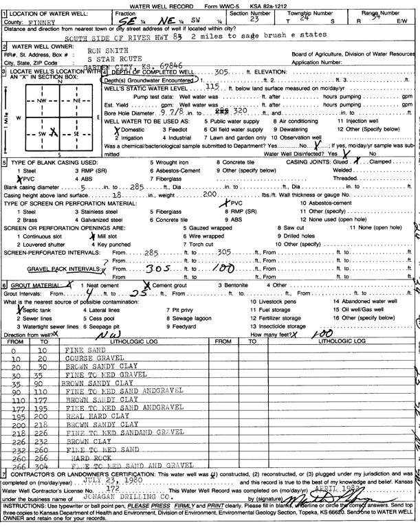
Specific Water Well Detail |
|
|
| Location Info | |||
| Owner: Smith, Ron | Status: Constructed | ||
| Location: T24S, R34W, Sec. 23, SE NE SW | County: Finney | ||
| Directions: S side of river on Hwy 83, 2 mi to Sage Brush Estates | |||
| Latitude: 37.9500869 | Longitude: -101.0210935 | Datum NAD 27 | |
| Latitude: 37.9501108 | Longitude: -101.0215387 | Datum NAD 83 | |
| Longitude and latitude calculated by Survey from township-range-section-quarter calls. Only good to within the quarter call accuracy. | |||
| View well on interactive map | |||
| General Info | ||
| Well Depth: 305 ft. | Elevation: ft. | |
| Static Water Level: 115 ft. | Est. Yield: gpm. | |
| Comp. Date: 23-Jul-1980 | Well Use: Domestic | |
| DWR Applic. #: | Other ID: | |
| Driller Info | ||
| Driller: Jonagan Water Well Service LLC | License #: 172 | |
| Scanned Form | View scan |
|
Chemical Sample Submitted?: No
Water Well disinfected?: | ||
| Ground water encountered: 0 ft. , 0 ft. , 0 ft. | ||
| Pump test data: Well water was 0 ft after 0 hours pumping 0 gpm | ||
| Casing Info | ||
| Casing Type:
Casing Joints: |
Diam: 0 in. to 0 ft
Diam: 0 in. to 0 ft Diam: 0 in. to 0 ft | |
| Casing height above land surface: in
Casing Weight: lbs/ft Wall thickness or gauge no.: | ||
| Screen and Perforation Info | ||
| Screen Type: | Screen Openings: | |
| Screen-perforated intervals | From: 285 ft to 305 ft
From: 0 ft to 0 ft From: 0 ft to 0 ft | |
| Gravel pack intervals | From: ft to ft | |
| Grout Info | ||
| Grout used: | From: 0 to 0 ft
From: 0 to 0 ft From: 0 to 0 ft | |
| Source of Possible Contamination | ||
| Source: | ||
| Direction from well: | Distance: 0 ft | |
| Lithologic Log
(Log data entered by KGS.) | ||
| From: 0 ft. to 10 ft. | fine sand | |
| From: 10 ft. to 20 ft. | coarse gravel | |
| From: 20 ft. to 30 ft. | brown sandy clay | |
| From: 30 ft. to 35 ft. | fine to med gravel | |
| From: 35 ft. to 90 ft. | brown sandy clay | |
| From: 90 ft. to 110 ft. | fine to medium sand and gravel | |
| From: 110 ft. to 177 ft. | brown sandy clay | |
| From: 177 ft. to 195 ft. | fine to medium sand and gravel | |
| From: 195 ft. to 200 ft. | real hard clay | |
| From: 200 ft. to 218 ft. | brown sandy clay | |
| From: 218 ft. to 226 ft. | fine to medium sand and gravel | |
| From: 226 ft. to 232 ft. | brown clay | |
| From: 232 ft. to 260 ft. | fine to medium sand | |
| From: 260 ft. to 266 ft. | hard rock | |
| From: 266 ft. to 304 ft. | fine to medium sand and gravel | |