|
|
|
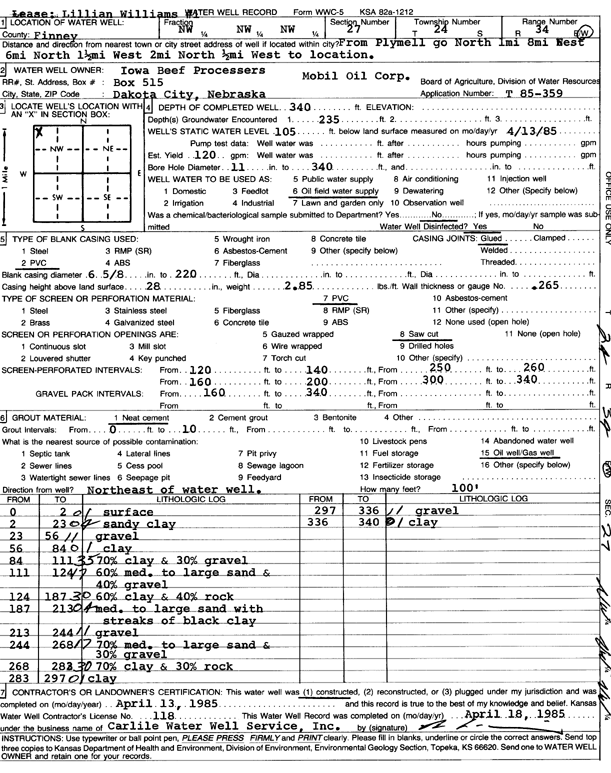
Specific Water Well Detail |
|
|
| Location Info | |||
| Owner: Mobil Oil Corp./Iowa Beef Processors | Status: Constructed | ||
| Location: T24S, R34W, Sec. 27, NW NW NW | County: Finney | ||
| Directions: from Plymell: 1 mi N, 8 mi W, 6 mi N, 1.5 mi W, 2 mi N, and 0.5 mi W into site | |||
| Latitude: 37.9445627 | Longitude: -101.0464267 | Datum NAD 27 | |
| Latitude: 37.9445861 | Longitude: -101.0468721 | Datum NAD 83 | |
| Longitude and latitude calculated by Survey from township-range-section-quarter calls. Only good to within the quarter call accuracy. | |||
| View well on interactive map | |||
| General Info | ||
| Well Depth: 340 ft. | Elevation: ft. | |
| Static Water Level: 105 ft. | Est. Yield: 120 gpm. | |
| Comp. Date: 13-Apr-1985 | Well Use: Oil Field Water Supply | |
| DWR Applic. #: T85-359 | Other ID: Lillian Williams 1 | |
| Driller Info | ||
| Driller: Bernard E. Carlile Water Well Service, Inc. | License #: 118 | |
| Scanned Form | View scan |
|
Chemical Sample Submitted?: No
Water Well disinfected?: | ||
| Ground water encountered: 235 ft. , 0 ft. , 0 ft. | ||
| Pump test data: Well water was 0 ft after 0 hours pumping 0 gpm | ||
| Casing Info | ||
| Casing Type: PVC
Casing Joints: |
Diam: 6 in. to 220 ft
Diam: 0 in. to 0 ft Diam: 0 in. to 0 ft | |
| Casing height above land surface: in
Casing Weight: lbs/ft Wall thickness or gauge no.: | ||
| Screen and Perforation Info | ||
| Screen Type: PVC | Screen Openings: Saw cut | |
| Screen-perforated intervals | From: 120 ft to 140 ft
From: 250 ft to 260 ft From: 160 ft to 200 ft | |
| Gravel pack intervals | From: ft to ft | |
| Grout Info | ||
| Grout used: Neat cement | From: 0 to 10 ft
From: 0 to 0 ft From: 0 to 0 ft | |
| Source of Possible Contamination | ||
| Source: Oil well/gas well | ||
| Direction from well: | Distance: 0 ft | |
| Lithologic Log
(Log data entered by KGS.) | ||
| From: 0 ft. to 2 ft. | surface | |
| From: 2 ft. to 23 ft. | sandy clay | |
| From: 23 ft. to 56 ft. | gravel | |
| From: 56 ft. to 84 ft. | clay | |
| From: 84 ft. to 111 ft. | 70% clay and 30% gravel | |
| From: 111 ft. to 124 ft. | 60% med. to large sand and 40% gravel | |
| From: 124 ft. to 187 ft. | 60% clay and 40% rock | |
| From: 187 ft. to 213 ft. | med. to large sand with streaks of black clay | |
| From: 213 ft. to 244 ft. | gravel | |
| From: 244 ft. to 268 ft. | 70% med. to large sand and 30% gravel | |
| From: 268 ft. to 283 ft. | 70% clay and 30% rock | |
| From: 283 ft. to 297 ft. | clay | |
| From: 297 ft. to 336 ft. | gravel | |
| From: 336 ft. to 340 ft. | clay | |