|
|
|
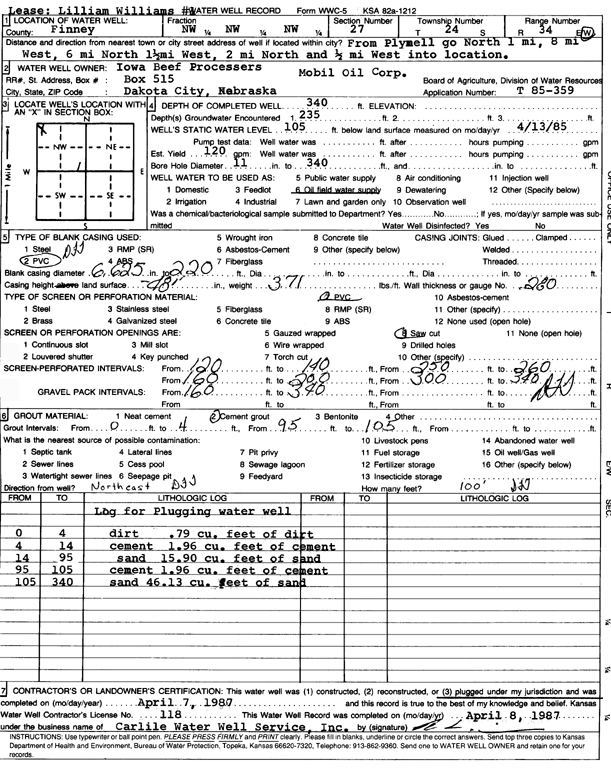
Specific Water Well Detail |
|
|
| Location Info | |||
| Owner: Mobil Oil Corp./Iowa Beef Processors | Status: Plugged | ||
| Location: T24S, R34W, Sec. 27, NW NW NW | County: Finney | ||
| Directions: from Plymell: 1 mi N, 8 mi W, 6 mi N, 1.5 mi W, 2 mi N, and 0.5 mi W into site | |||
| Latitude: 37.9445627 | Longitude: -101.0464267 | Datum NAD 27 | |
| Latitude: 37.9445861 | Longitude: -101.0468721 | Datum NAD 83 | |
| Longitude and latitude calculated by Survey from township-range-section-quarter calls. Only good to within the quarter call accuracy. | |||
| View well on interactive map | |||
| General Info | ||
| Well Depth: 340 ft. | Elevation: ft. | |
| Static Water Level: 105 ft. | Est. Yield: 120 gpm. | |
| Comp. Date: 07-Apr-1986 | Well Use: Oil Field Water Supply | |
| DWR Applic. #: T85-359 | Other ID: | |
| Driller Info | ||
| Driller: Bernard E. Carlile Water Well Service, Inc. | License #: 118 | |
| Scanned Form | View scan |
| Casing Info | ||
|
Casing Type: PVC
Diam: 6 in. Casing height above land surface: in | ||
| Grout Info | ||
| Grout used: Cement grout | From: 0 to 4 ft
From: 95 to 105 ft From: 0 to 0 ft | |
| Source of Possible Contamination | ||
| Source: | ||
| Direction from well: | Distance: 0 ft | |