|
|
|
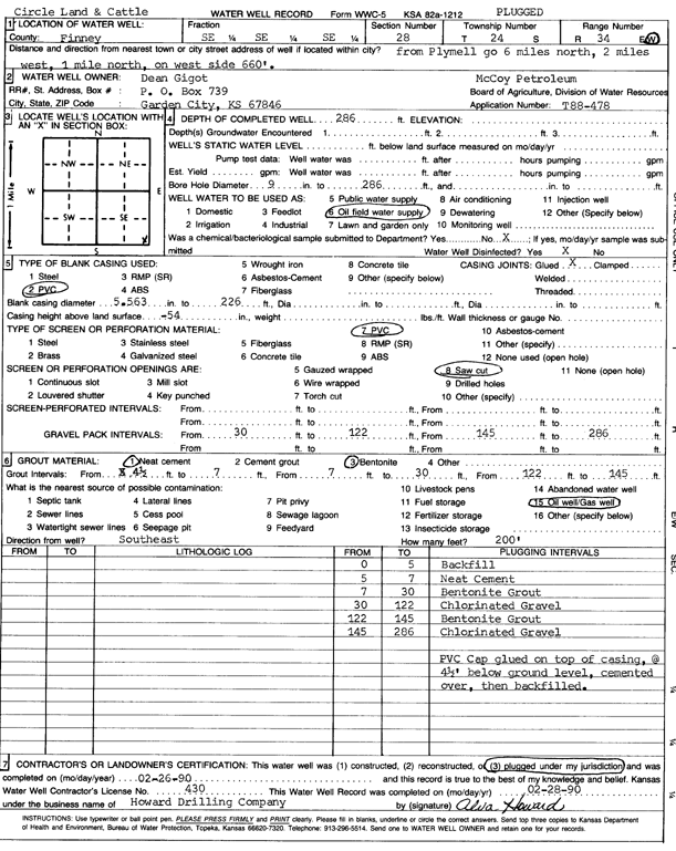
Specific Water Well Detail |
|
|
| Location Info | |||
| Owner: Gigot, Dean | Status: Plugged | ||
| Location: T24S, R34W, Sec. 28, SE SE SE | County: Finney | ||
| Directions: from Plymell: 6 mi N, 2 mi W, 1 mi N, and 660 feet on W side | |||
| Latitude: 37.9318175 | Longitude: -101.0486391 | Datum NAD 27 | |
| Latitude: 37.9318408 | Longitude: -101.0490846 | Datum NAD 83 | |
| Longitude and latitude calculated by Survey from township-range-section-quarter calls. Only good to within the quarter call accuracy. | |||
| View well on interactive map | |||
| General Info | ||
| Well Depth: 286 ft. | Elevation: ft. | |
| Static Water Level: ft. | Est. Yield: gpm. | |
| Comp. Date: 26-Feb-1990 | Well Use: Oil Field Water Supply | |
| DWR Applic. #: T88-478 | Other ID: | |
| Links | |
| No Wizard information available. | |
| View info from WIMAS Water Right Data base... | |
| Driller Info | ||
| Driller: Howard Drilling Co. | License #: 430 | |
| Scanned Form | View scan |
| Casing Info | ||
|
Casing Type: PVC
Diam: 5 in. Casing height above land surface: in | ||
| Grout Info | ||
| Grout used: Neat cement, Bentonite | From: 7 to 7 ft
From: 7 to 30 ft From: 122 to 145 ft | |
| Source of Possible Contamination | ||
| Source: Oil well/gas well | ||
| Direction from well: | Distance: 0 ft | |