|
|
|
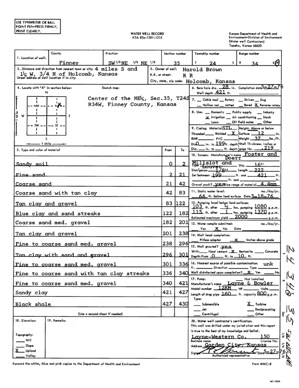
Specific Water Well Detail |
|
|
| Location Info | |||
| Owner: Brown, Harold | Status: Constructed | ||
| Location: T24S, R34W, Sec. 35, SW NE NE | County: Finney | ||
| Directions: from Holcomb, 4 mi S, 1.25 mi W, and 0.75 mi N | |||
| Latitude: 37.9283045 | Longitude: -101.0139444 | Datum NAD 27 | |
| Latitude: 37.9283285 | Longitude: -101.0143897 | Datum NAD 83 | |
| Longitude and latitude calculated by Survey from township-range-section-quarter calls. Only good to within the quarter call accuracy. | |||
| View well on interactive map | |||
| General Info | ||
| Well Depth: 421 ft. | Elevation: ft. | |
| Static Water Level: 66 ft. | Est. Yield: 2000 gpm. | |
| Comp. Date: 27-May-1976 | Well Use: Irrigation | |
| DWR Applic. #: | Other ID: | |
| Links | |
| View info from Wizard Water Level Data base... | |
| View info from WIMAS Water Right Data base... | |
| Driller Info | ||
| Driller: Layne-Western | License #: 150 | |
| Scanned Form | View scan |
|
Chemical Sample Submitted?: No
Water Well disinfected?: | ||
| Ground water encountered: 0 ft. , 0 ft. , 0 ft. | ||
| Pump test data: Well water was 0 ft after 0 hours pumping 0 gpm | ||
| Casing Info | ||
| Casing Type:
Casing Joints: |
Diam: 0 in. to 0 ft
Diam: 0 in. to 0 ft Diam: 0 in. to 0 ft | |
| Casing height above land surface: in
Casing Weight: lbs/ft Wall thickness or gauge no.: | ||
| Screen and Perforation Info | ||
| Screen Type: | Screen Openings: | |
| Screen-perforated intervals | From: 199 ft to 421 ft
From: 0 ft to 0 ft From: 0 ft to 0 ft | |
| Gravel pack intervals | From: ft to ft | |
| Grout Info | ||
| Grout used: | From: 0 to 0 ft
From: 0 to 0 ft From: 0 to 0 ft | |
| Source of Possible Contamination | ||
| Source: | ||
| Direction from well: | Distance: 0 ft | |
| Lithologic Log
(Log data entered by KGS.) | ||
| From: 0 ft. to 2 ft. | sandy soil | |
| From: 2 ft. to 21 ft. | fine sand | |
| From: 21 ft. to 42 ft. | coarse sand | |
| From: 42 ft. to 83 ft. | coarse sand with tan clay | |
| From: 83 ft. to 122 ft. | tan clay and gravel | |
| From: 122 ft. to 182 ft. | blue clay and sand streaks | |
| From: 182 ft. to 201 ft. | coarse sand medium gravel | |
| From: 201 ft. to 238 ft. | tan clay and gravel | |
| From: 238 ft. to 296 ft. | fine to coarse sand medium gravel | |
| From: 296 ft. to 301 ft. | tan clay with sand and gravel | |
| From: 301 ft. to 336 ft. | fine to coarse sand medium gravel | |
| From: 336 ft. to 340 ft. | fine to coarse sand with tan clay streaks | |
| From: 340 ft. to 421 ft. | fine to coarse sand medium gravel | |
| From: 421 ft. to 427 ft. | sandy clay | |
| From: 427 ft. to 430 ft. | black shale | |