|
|
|
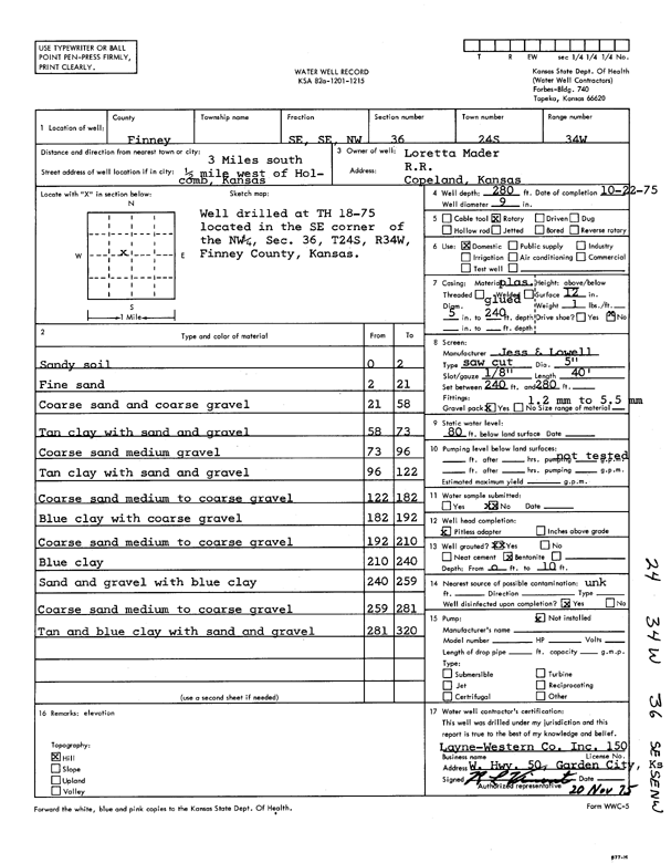
Specific Water Well Detail |
|
|
| Location Info | |||
| Owner: Mader, Loretta | Status: Constructed | ||
| Location: T24S, R34W, Sec. 36, SE SE NW | County: Finney | ||
| Directions: from Holcomb, 3 mi S and 0.5 mi W | |||
| Latitude: 37.9247732 | Longitude: -101.0025539 | Datum NAD 27 | |
| Latitude: 37.9247973 | Longitude: -101.002999 | Datum NAD 83 | |
| Longitude and latitude calculated by Survey from township-range-section-quarter calls. Only good to within the quarter call accuracy. | |||
| View well on interactive map | |||
| General Info | ||
| Well Depth: 280 ft. | Elevation: ft. | |
| Static Water Level: 80 ft. | Est. Yield: gpm. | |
| Comp. Date: 22-Oct-1975 | Well Use: Domestic | |
| DWR Applic. #: | Other ID: | |
| Driller Info | ||
| Driller: Layne-Western | License #: 150 | |
| Scanned Form | View scan |
|
Chemical Sample Submitted?: No
Water Well disinfected?: | ||
| Ground water encountered: 0 ft. , 0 ft. , 0 ft. | ||
| Pump test data: Well water was 0 ft after 0 hours pumping 0 gpm | ||
| Casing Info | ||
| Casing Type:
Casing Joints: |
Diam: 0 in. to 0 ft
Diam: 0 in. to 0 ft Diam: 0 in. to 0 ft | |
| Casing height above land surface: in
Casing Weight: lbs/ft Wall thickness or gauge no.: | ||
| Screen and Perforation Info | ||
| Screen Type: | Screen Openings: | |
| Screen-perforated intervals | From: 240 ft to 280 ft
From: 0 ft to 0 ft From: 0 ft to 0 ft | |
| Gravel pack intervals | From: ft to ft | |
| Grout Info | ||
| Grout used: | From: 0 to 0 ft
From: 0 to 0 ft From: 0 to 0 ft | |
| Source of Possible Contamination | ||
| Source: | ||
| Direction from well: | Distance: 0 ft | |
| Lithologic Log
(Log data entered by KGS.) | ||
| From: 0 ft. to 2 ft. | sandy soil | |
| From: 2 ft. to 21 ft. | fine sand | |
| From: 21 ft. to 58 ft. | coarse sand and coarse gravel | |
| From: 58 ft. to 73 ft. | tan clay with sand and gravel | |
| From: 73 ft. to 96 ft. | coarse sand medium gravel | |
| From: 96 ft. to 122 ft. | tan clay with sand and gravel | |
| From: 122 ft. to 182 ft. | coarse sand medium to coarse gravel | |
| From: 182 ft. to 192 ft. | blue clay with coarse gravel | |
| From: 192 ft. to 210 ft. | coarse sand medium to coarse gravel | |
| From: 210 ft. to 240 ft. | blue clay | |
| From: 240 ft. to 259 ft. | sand and gravel with blue clay | |
| From: 259 ft. to 281 ft. | coarse sand medium to coarse gravel | |
| From: 281 ft. to 320 ft. | tan and blue clay with sand and gravel | |