|
|
|
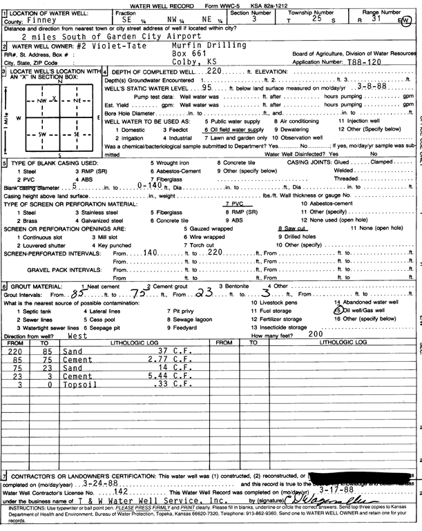
Specific Water Well Detail |
|
|
| Location Info | |||
| Owner: Murfin Drilling Co. | Status: Plugged | ||
| Location: T25S, R31W, Sec. 3, SE NW NE | County: Finney | ||
| Directions: from Garden City Airport, 2 mi S | |||
| Latitude: 37.9132944 | Longitude: -100.7066483 | Datum NAD 27 | |
| Latitude: 37.9133167 | Longitude: -100.7070822 | Datum NAD 83 | |
| Longitude and latitude calculated by Survey from township-range-section-quarter calls. Only good to within the quarter call accuracy. | |||
| View well on interactive map | |||
| General Info | ||
| Well Depth: 220 ft. | Elevation: ft. | |
| Static Water Level: 95 ft. | Est. Yield: gpm. | |
| Comp. Date: 24-Mar-1988 | Well Use: Oil Field Water Supply | |
| DWR Applic. #: T88-120 | Other ID: Violet-Tate 2 | |
| Links | |
| No Wizard information available. | |
| View info from WIMAS Water Right Data base... | |
| Driller Info | ||
| Driller: T & W Water Well Serv., Inc. | License #: 142 | |
| Scanned Form | View scan |
| Casing Info | ||
|
Casing Type: PVC
Diam: 5 in. Casing height above land surface: in | ||
| Grout Info | ||
| Grout used: | From: 85 to 75 ft
From: 23 to 3 ft From: 0 to 0 ft | |
| Source of Possible Contamination | ||
| Source: Abandoned water well | ||
| Direction from well: | Distance: 0 ft | |