|
|
|
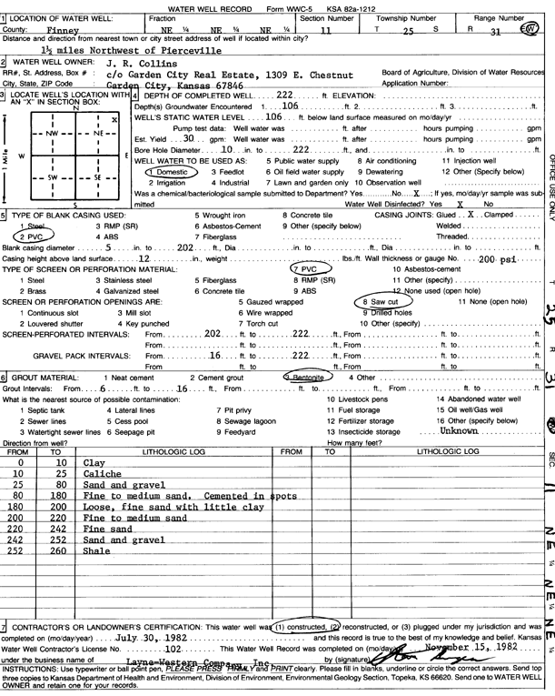
Specific Water Well Detail |
|
|
| Location Info | |||
| Owner: Collins, J.R. | Status: Constructed | ||
| Location: T25S, R31W, Sec. 11, NE NE NE | County: Finney | ||
| Directions: from Pierceville, 1.5 mi NW | |||
| Latitude: 37.900395 | Longitude: -100.6839566 | Datum NAD 27 | |
| Latitude: 37.9004172 | Longitude: -100.6843899 | Datum NAD 83 | |
| Longitude and latitude calculated by Survey from township-range-section-quarter calls. Only good to within the quarter call accuracy. | |||
| View well on interactive map | |||
| General Info | ||
| Well Depth: 222 ft. | Elevation: ft. | |
| Static Water Level: 106 ft. | Est. Yield: 30 gpm. | |
| Comp. Date: 30-Jul-1982 | Well Use: Domestic | |
| DWR Applic. #: | Other ID: | |
| Driller Info | ||
| Driller: Layne-Christensen Co. | License #: 102 | |
| Scanned Form | View scan |
|
Chemical Sample Submitted?: No
Water Well disinfected?: | ||
| Ground water encountered: 0 ft. , 0 ft. , 0 ft. | ||
| Pump test data: Well water was 0 ft after 0 hours pumping 0 gpm | ||
| Casing Info | ||
| Casing Type:
Casing Joints: |
Diam: 0 in. to 0 ft
Diam: 0 in. to 0 ft Diam: 0 in. to 0 ft | |
| Casing height above land surface: in
Casing Weight: lbs/ft Wall thickness or gauge no.: | ||
| Screen and Perforation Info | ||
| Screen Type: | Screen Openings: | |
| Screen-perforated intervals | From: 202 ft to 222 ft
From: 0 ft to 0 ft From: 0 ft to 0 ft | |
| Gravel pack intervals | From: ft to ft | |
| Grout Info | ||
| Grout used: | From: 0 to 0 ft
From: 0 to 0 ft From: 0 to 0 ft | |
| Source of Possible Contamination | ||
| Source: | ||
| Direction from well: | Distance: 0 ft | |
| Lithologic Log
(Log data entered by KGS.) | ||
| From: 0 ft. to 10 ft. | clay | |
| From: 10 ft. to 25 ft. | caliche | |
| From: 25 ft. to 80 ft. | sand and gravel | |
| From: 80 ft. to 180 ft. | fine to medium sand. cemented in spots | |
| From: 180 ft. to 200 ft. | loose, fine sand with little clay | |
| From: 200 ft. to 220 ft. | fine to medium sand | |
| From: 220 ft. to 242 ft. | fine sand | |
| From: 242 ft. to 252 ft. | sand and gravel | |
| From: 252 ft. to 260 ft. | shale | |