|
|
|
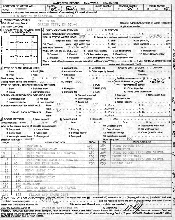
Specific Water Well Detail |
|
|
| Location Info | |||
| Owner: Brimm, Jim | Status: Constructed | ||
| Location: T25S, R31W, Sec. 11, NE | County: Finney | ||
| Directions: 2 mi W on Hwy 50 of Pierceville, .25 mi E | |||
| Latitude: 37.8977119 | Longitude: -100.687337 | Datum NAD 27 | |
| Latitude: 37.8977342 | Longitude: -100.6877704 | Datum NAD 83 | |
| Longitude and latitude calculated by Survey from township-range-section-quarter calls. Only good to within the quarter call accuracy. | |||
| View well on interactive map | |||
| General Info | ||
| Well Depth: 252 ft. | Elevation: ft. | |
| Static Water Level: 105 ft. | Est. Yield: gpm. | |
| Comp. Date: 26-Apr-1983 | Well Use: Domestic | |
| DWR Applic. #: | Other ID: | |
| Driller Info | ||
| Driller: Jonagan Drilling Co. | License #: 172 | |
| Scanned Form | View scan |
|
Chemical Sample Submitted?: No
Water Well disinfected?: | ||
| Ground water encountered: 0 ft. , 0 ft. , 0 ft. | ||
| Pump test data: Well water was 0 ft after 0 hours pumping 0 gpm | ||
| Casing Info | ||
| Casing Type:
Casing Joints: |
Diam: 0 in. to 0 ft
Diam: 0 in. to 0 ft Diam: 0 in. to 0 ft | |
| Casing height above land surface: in
Casing Weight: lbs/ft Wall thickness or gauge no.: | ||
| Screen and Perforation Info | ||
| Screen Type: | Screen Openings: | |
| Screen-perforated intervals | From: 226 ft to 252 ft
From: 0 ft to 0 ft From: 0 ft to 0 ft | |
| Gravel pack intervals | From: ft to ft | |
| Grout Info | ||
| Grout used: | From: 0 to 0 ft
From: 0 to 0 ft From: 0 to 0 ft | |
| Source of Possible Contamination | ||
| Source: | ||
| Direction from well: | Distance: 0 ft | |
| Lithologic Log
(Log data entered by KGS.) | ||
| From: 0 ft. to 7 ft. | top soil | |
| From: 7 ft. to 10 ft. | brown sandy clay | |
| From: 10 ft. to 25 ft. | fine to medium sand and gravel | |
| From: 25 ft. to 28 ft. | hard rock | |
| From: 28 ft. to 35 ft. | fine to medium sand and gravel | |
| From: 35 ft. to 40 ft. | rock and fine sand | |
| From: 40 ft. to 55 ft. | fine to medium sand and gravel | |
| From: 55 ft. to 60 ft. | brown sandy clay | |
| From: 60 ft. to 111 ft. | fine to medium sand | |
| From: 111 ft. to 125 ft. | brown sandy clay | |
| From: 125 ft. to 130 ft. | fine sand | |
| From: 130 ft. to 135 ft. | hard rock | |
| From: 135 ft. to 140 ft. | fine to medium sand and gravel | |
| From: 140 ft. to 148 ft. | brown sandy clay | |
| From: 148 ft. to 172 ft. | yellow and brown clay | |
| From: 172 ft. to 185 ft. | fine to medium sand | |
| From: 185 ft. to 187 ft. | hard rock | |
| From: 187 ft. to 205 ft. | fine to medium sand and gravel | |
| From: 205 ft. to 207 ft. | brown sandy clay | |
| From: 207 ft. to 250 ft. | fine to medium sand and gravel | |
| From: 250 ft. to 253 ft. | yellow clay | |