|
|
|
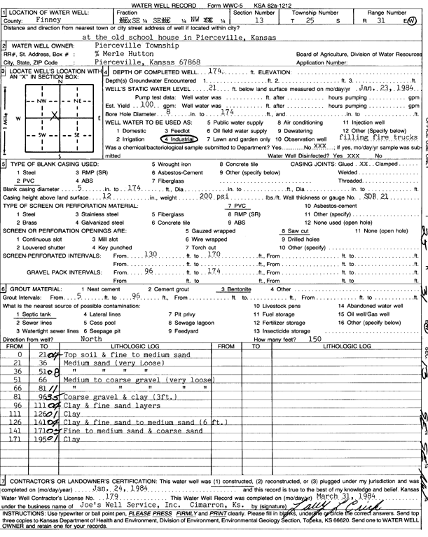
Specific Water Well Detail |
|
|
| Location Info | |||
| Owner: Pierceville Township | Status: Constructed | ||
| Location: T25S, R31W, Sec. 13, SE SE NW | County: Finney | ||
| Directions: at the old school house in Pierceville | |||
| Latitude: 37.8804575 | Longitude: -100.6747794 | Datum NAD 27 | |
| Latitude: 37.8804799 | Longitude: -100.6752125 | Datum NAD 83 | |
| Longitude and latitude calculated by Survey from township-range-section-quarter calls. Only good to within the quarter call accuracy. | |||
| View well on interactive map | |||
| General Info | ||
| Well Depth: 174 ft. | Elevation: ft. | |
| Static Water Level: 21 ft. | Est. Yield: 100 gpm. | |
| Comp. Date: 24-Jan-1984 | Well Use: Industrial | |
| DWR Applic. #: | Other ID: | |
| Links | |
| View info from Wizard Water Level Data base... | |
| No WIMAS information available. | |
| Driller Info | ||
| Driller: Joe's Well Service, Inc. | License #: 179 | |
| Scanned Form | View scan |
|
Chemical Sample Submitted?: No
Water Well disinfected?: | ||
| Ground water encountered: 0 ft. , 0 ft. , 0 ft. | ||
| Pump test data: Well water was 0 ft after 0 hours pumping 0 gpm | ||
| Casing Info | ||
| Casing Type: PVC
Casing Joints: |
Diam: 5 in. to 174 ft
Diam: 0 in. to 0 ft Diam: 0 in. to 0 ft | |
| Casing height above land surface: in
Casing Weight: lbs/ft Wall thickness or gauge no.: | ||
| Screen and Perforation Info | ||
| Screen Type: PVC | Screen Openings: Saw cut | |
| Screen-perforated intervals | From: 130 ft to 170 ft
From: 0 ft to 0 ft From: 0 ft to 0 ft | |
| Gravel pack intervals | From: ft to ft | |
| Grout Info | ||
| Grout used: Bentonite | From: 5 to 96 ft
From: 0 to 0 ft From: 0 to 0 ft | |
| Source of Possible Contamination | ||
| Source: Septic Tank | ||
| Direction from well: | Distance: 0 ft | |
| Lithologic Log
(Log data entered by KGS.) | ||
| From: 0 ft. to 21 ft. | top soil and fine to medium sand | |
| From: 21 ft. to 36 ft. | medium sand (very loose) | |
| From: 36 ft. to 51 ft. | medium sand (very loose) | |
| From: 51 ft. to 66 ft. | medium to coarse gravel (very loose) | |
| From: 66 ft. to 81 ft. | medium to coarse gravel (very loose) | |
| From: 81 ft. to 96 ft. | coarse gravel and clay (3 ft.) | |
| From: 96 ft. to 111 ft. | clay and fine sand layers | |
| From: 111 ft. to 126 ft. | clay | |
| From: 126 ft. to 141 ft. | clay and fine sand to medium sand (6 ft.) | |
| From: 141 ft. to 171 ft. | fine to medium sand and coarse sand | |
| From: 171 ft. to 195 ft. | clay | |