|
|
|
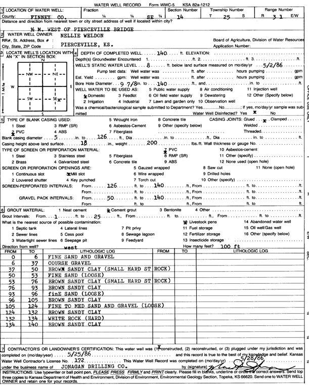
Specific Water Well Detail |
|
|
| Location Info | |||
| Owner: Weldon, Nellie | Status: Constructed | ||
| Location: T25S, R31W, Sec. 14, SE | County: Finney | ||
| Directions: .5 mi W of Pierceville bridge | |||
| Latitude: 37.8760566 | Longitude: -100.6873055 | Datum NAD 27 | |
| Latitude: 37.876079 | Longitude: -100.6877392 | Datum NAD 83 | |
| Longitude and latitude calculated by Survey from township-range-section-quarter calls. Only good to within the quarter call accuracy. | |||
| View well on interactive map | |||
| General Info | ||
| Well Depth: 140 ft. | Elevation: ft. | |
| Static Water Level: 8 ft. | Est. Yield: gpm. | |
| Comp. Date: 25-May-1986 | Well Use: Domestic | |
| DWR Applic. #: | Other ID: | |
| Driller Info | ||
| Driller: Jonagan Drilling Co. | License #: 172 | |
| Scanned Form | View scan |
|
Chemical Sample Submitted?:
Water Well disinfected?: | ||
| Ground water encountered: 0 ft. , 0 ft. , 0 ft. | ||
| Pump test data: Well water was 0 ft after 0 hours pumping 0 gpm | ||
| Casing Info | ||
| Casing Type: PVC
Casing Joints: |
Diam: 5 in. to 126 ft
Diam: 0 in. to 0 ft Diam: 0 in. to 0 ft | |
| Casing height above land surface: in
Casing Weight: lbs/ft Wall thickness or gauge no.: | ||
| Screen and Perforation Info | ||
| Screen Type: PVC | Screen Openings: Mill slot | |
| Screen-perforated intervals | From: 126 ft to 140 ft
From: 0 ft to 0 ft From: 0 ft to 0 ft | |
| Gravel pack intervals | From: ft to ft | |
| Grout Info | ||
| Grout used: Cement grout | From: 1 to 25 ft
From: 0 to 0 ft From: 0 to 0 ft | |
| Source of Possible Contamination | ||
| Source: Livestock pens | ||
| Direction from well: | Distance: 0 ft | |
| Lithologic Log
(Log data entered by KGS.) | ||
| From: 0 ft. to 6 ft. | fine sand and gravel | |
| From: 6 ft. to 37 ft. | coarse gravel | |
| From: 37 ft. to 50 ft. | brown sandy clay (small hard st rock) | |
| From: 50 ft. to 53 ft. | fine sand (loose) | |
| From: 53 ft. to 76 ft. | brown sandy clay (small hard st rock) | |
| From: 76 ft. to 93 ft. | brown sandy clay | |
| From: 93 ft. to 96 ft. | fine sand (loose) | |
| From: 96 ft. to 105 ft. | brown sandy clay | |
| From: 105 ft. to 124 ft. | fine to medium sand and gravel (loose) | |
| From: 124 ft. to 132 ft. | brown sandy clay | |
| From: 132 ft. to 134 ft. | white rock (hard) | |
| From: 134 ft. to 140 ft. | brown sandy clay | |