|
|
|
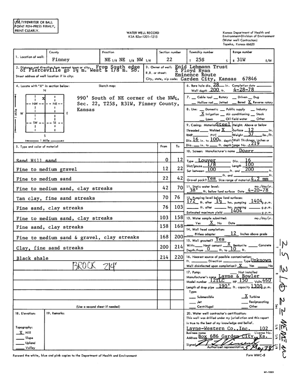
Specific Water Well Detail |
|
|
| Location Info | |||
| Owner: Enid Lehmann Trust | Status: Constructed | ||
| Location: T25S, R31W, Sec. 22, NE NE NW | County: Finney | ||
| Directions: from S edge of Pierceville: 1.5 mi W and 0.13 mi S | |||
| Latitude: 37.8716987 | Longitude: -100.7111467 | Datum NAD 27 | |
| Latitude: 37.8717214 | Longitude: -100.7115812 | Datum NAD 83 | |
| Longitude and latitude calculated by Survey from township-range-section-quarter calls. Only good to within the quarter call accuracy. | |||
| View well on interactive map | |||
| General Info | ||
| Well Depth: 200 ft. | Elevation: ft. | |
| Static Water Level: 38 ft. | Est. Yield: 1404 gpm. | |
| Comp. Date: 28-Apr-1978 | Well Use: Irrigation | |
| DWR Applic. #: | Other ID: | |
| Links | |
| View info from Wizard Water Level Data base... | |
| View info from WIMAS Water Right Data base... | |
| Driller Info | ||
| Driller: Layne-Western | License #: 102 | |
| Scanned Form | View scan |
|
Chemical Sample Submitted?: No
Water Well disinfected?: | ||
| Ground water encountered: 0 ft. , 0 ft. , 0 ft. | ||
| Pump test data: Well water was 0 ft after 0 hours pumping 0 gpm | ||
| Casing Info | ||
| Casing Type:
Casing Joints: |
Diam: 0 in. to 0 ft
Diam: 0 in. to 0 ft Diam: 0 in. to 0 ft | |
| Casing height above land surface: in
Casing Weight: lbs/ft Wall thickness or gauge no.: | ||
| Screen and Perforation Info | ||
| Screen Type: | Screen Openings: | |
| Screen-perforated intervals | From: 100 ft to 200 ft
From: 0 ft to 0 ft From: 0 ft to 0 ft | |
| Gravel pack intervals | From: ft to ft | |
| Grout Info | ||
| Grout used: | From: 0 to 0 ft
From: 0 to 0 ft From: 0 to 0 ft | |
| Source of Possible Contamination | ||
| Source: | ||
| Direction from well: | Distance: 0 ft | |
| Lithologic Log
(Log data entered by KGS.) | ||
| From: 0 ft. to 12 ft. | sand hill sand | |
| From: 12 ft. to 22 ft. | fine to medium gravel | |
| From: 22 ft. to 42 ft. | fine to medium sand | |
| From: 42 ft. to 70 ft. | fine to medium sand, clay streaks | |
| From: 70 ft. to 76 ft. | tan clay, fine sand streaks | |
| From: 76 ft. to 103 ft. | fine sand, clay streaks | |
| From: 103 ft. to 158 ft. | fine to medium sand, clay streaks | |
| From: 158 ft. to 168 ft. | fine sand, clay streaks | |
| From: 168 ft. to 200 ft. | fine to medium sand and gravel, clay streaks | |
| From: 200 ft. to 214 ft. | clay, fine sand streaks | |
| From: 214 ft. to 220 ft. | black shale | |