|
|
|
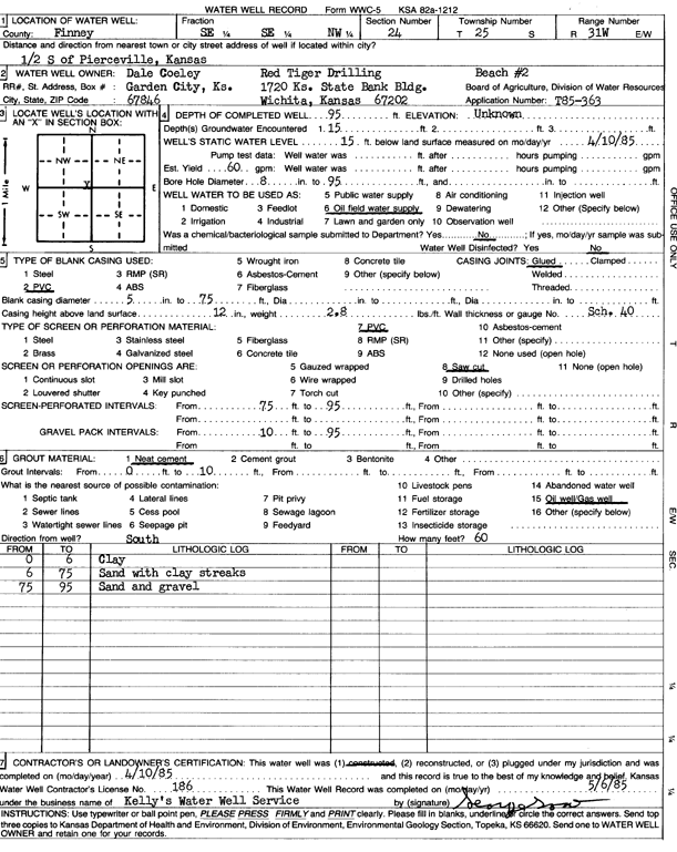
Specific Water Well Detail |
|
|
| Location Info | |||
| Owner: Red Tiger Drilling/Dale Corley | Status: Constructed | ||
| Location: T25S, R31W, Sec. 24, SE SE NW | County: Finney | ||
| Directions: from Pierceville, 0.5 mi S | |||
| Latitude: 37.8660096 | Longitude: -100.6748303 | Datum NAD 27 | |
| Latitude: 37.8660321 | Longitude: -100.6752636 | Datum NAD 83 | |
| Longitude and latitude calculated by Survey from township-range-section-quarter calls. Only good to within the quarter call accuracy. | |||
| View well on interactive map | |||
| General Info | ||
| Well Depth: 95 ft. | Elevation: ft. | |
| Static Water Level: 15 ft. | Est. Yield: 60 gpm. | |
| Comp. Date: 10-Apr-1985 | Well Use: Oil Field Water Supply | |
| DWR Applic. #: T85-363 | Other ID: Beach 2 | |
| Driller Info | ||
| Driller: Kelly's Water Well Service, Inc. | License #: 186 | |
| Scanned Form | View scan |
|
Chemical Sample Submitted?: No
Water Well disinfected?: | ||
| Ground water encountered: 15 ft. , 0 ft. , 0 ft. | ||
| Pump test data: Well water was 0 ft after 0 hours pumping 0 gpm | ||
| Casing Info | ||
| Casing Type: PVC
Casing Joints: |
Diam: 5 in. to 75 ft
Diam: 0 in. to 0 ft Diam: 0 in. to 0 ft | |
| Casing height above land surface: in
Casing Weight: lbs/ft Wall thickness or gauge no.: | ||
| Screen and Perforation Info | ||
| Screen Type: PVC | Screen Openings: Saw cut | |
| Screen-perforated intervals | From: 75 ft to 95 ft
From: 0 ft to 0 ft From: 0 ft to 0 ft | |
| Gravel pack intervals | From: ft to ft | |
| Grout Info | ||
| Grout used: Neat cement | From: 0 to 10 ft
From: 0 to 0 ft From: 0 to 0 ft | |
| Source of Possible Contamination | ||
| Source: Oil well/gas well | ||
| Direction from well: | Distance: 0 ft | |
| Lithologic Log
(Log data entered by KGS.) | ||
| From: 0 ft. to 6 ft. | clay | |
| From: 6 ft. to 75 ft. | sand with clay streaks | |
| From: 75 ft. to 95 ft. | sand and gravel | |