|
|
|
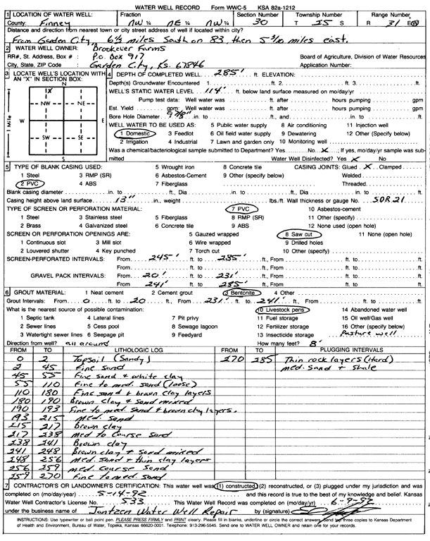
Specific Water Well Detail |
|
|
| Location Info | |||
| Owner: Brookover Farms | Status: Constructed | ||
| Location: T25S, R31W, Sec. 30, NW NE NW | County: Finney | ||
| Directions: from Garden City: 6.5 mi S on 83, 5.3 mi E | |||
| Latitude: 37.8572979 | Longitude: -100.7681158 | Datum NAD 27 | |
| Latitude: 37.8573211 | Longitude: -100.7685525 | Datum NAD 83 | |
| Longitude and latitude calculated by Survey from township-range-section-quarter calls. Only good to within the quarter call accuracy. | |||
| View well on interactive map | |||
| General Info | ||
| Well Depth: 285 ft. | Elevation: ft. | |
| Static Water Level: 114 ft. | Est. Yield: gpm. | |
| Comp. Date: 14-May-1992 | Well Use: Domestic | |
| DWR Applic. #: | Other ID: | |
| Driller Info | ||
| Driller: Jantzen Water Well | License #: 533 | |
| Scanned Form | View scan |
|
Chemical Sample Submitted?: No
Water Well disinfected?: | ||
| Ground water encountered: 0 ft. , 0 ft. , 0 ft. | ||
| Pump test data: Well water was 0 ft after 0 hours pumping 0 gpm | ||
| Casing Info | ||
| Casing Type: PVC
Casing Joints: |
Diam: 5 in. to 0 ft
Diam: 0 in. to 0 ft Diam: 0 in. to 0 ft | |
| Casing height above land surface: in
Casing Weight: lbs/ft Wall thickness or gauge no.: | ||
| Screen and Perforation Info | ||
| Screen Type: PVC | Screen Openings: Saw cut | |
| Screen-perforated intervals | From: 245 ft to 285 ft
From: 0 ft to 0 ft From: 0 ft to 0 ft | |
| Gravel pack intervals | From: ft to ft | |
| Grout Info | ||
| Grout used: Bentonite | From: 0 to 20 ft
From: 231 to 241 ft From: 0 to 0 ft | |
| Source of Possible Contamination | ||
| Source: Livestock pens | ||
| Direction from well: | Distance: 0 ft | |
| Lithologic Log
(Log data entered by KGS.) | ||
| From: 0 ft. to 2 ft. | topsoil (sandy) | |
| From: 2 ft. to 45 ft. | fine sand | |
| From: 45 ft. to 55 ft. | fine sand and white clay | |
| From: 55 ft. to 110 ft. | fine to medium sand (loose) | |
| From: 110 ft. to 180 ft. | fine sand and brown clay layers | |
| From: 180 ft. to 190 ft. | brown clay and sand mixed | |
| From: 190 ft. to 193 ft. | fine to medium sand and brown clay layers | |
| From: 193 ft. to 215 ft. | medium sand | |
| From: 215 ft. to 217 ft. | brown clay | |
| From: 217 ft. to 238 ft. | med to coarse sand | |
| From: 238 ft. to 241 ft. | brown clay | |
| From: 241 ft. to 248 ft. | brown clay and sand mixed | |
| From: 248 ft. to 256 ft. | medium sand and thin clay layers | |
| From: 256 ft. to 259 ft. | medium coarse sand | |
| From: 259 ft. to 270 ft. | fine to medium sand | |
| From: 270 ft. to 285 ft. | thin rock layers (hard) medium sand and shale | |