|
|
|
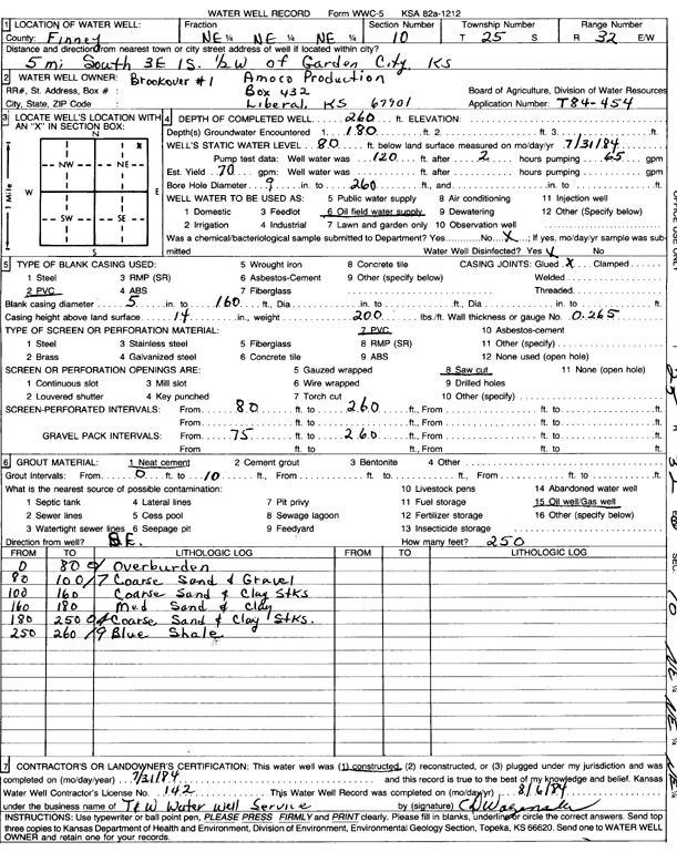
Specific Water Well Detail |
|
|
| Location Info | |||
| Owner: Amoco Production | Status: Constructed | ||
| Location: T25S, R32W, Sec. 10, NE NE NE | County: Finney | ||
| Directions: from Garden City, 5 mi S, 3 mi E, 1 mi S, and 0.5 mi W | |||
| Latitude: 37.9012899 | Longitude: -100.8114961 | Datum NAD 27 | |
| Latitude: 37.9013129 | Longitude: -100.8119341 | Datum NAD 83 | |
| Longitude and latitude calculated by Survey from township-range-section-quarter calls. Only good to within the quarter call accuracy. | |||
| View well on interactive map | |||
| General Info | ||
| Well Depth: 260 ft. | Elevation: ft. | |
| Static Water Level: 80 ft. | Est. Yield: 70 gpm. | |
| Comp. Date: 31-Jul-1984 | Well Use: Oil Field Water Supply | |
| DWR Applic. #: T84-454 | Other ID: Brookover 1 | |
| Driller Info | ||
| Driller: T & W Water Well Serv., Inc. | License #: 142 | |
| Scanned Form | View scan |
|
Chemical Sample Submitted?: No
Water Well disinfected?: | ||
| Ground water encountered: 180 ft. , 0 ft. , 0 ft. | ||
| Pump test data: Well water was 120 ft after 2 hours pumping 65 gpm | ||
| Casing Info | ||
| Casing Type: PVC
Casing Joints: |
Diam: 5 in. to 160 ft
Diam: 0 in. to 0 ft Diam: 0 in. to 0 ft | |
| Casing height above land surface: in
Casing Weight: lbs/ft Wall thickness or gauge no.: | ||
| Screen and Perforation Info | ||
| Screen Type: PVC | Screen Openings: Saw cut | |
| Screen-perforated intervals | From: 80 ft to 260 ft
From: 0 ft to 0 ft From: 0 ft to 0 ft | |
| Gravel pack intervals | From: ft to ft | |
| Grout Info | ||
| Grout used: Neat cement | From: 0 to 10 ft
From: 0 to 0 ft From: 0 to 0 ft | |
| Source of Possible Contamination | ||
| Source: Oil well/gas well | ||
| Direction from well: | Distance: 0 ft | |
| Lithologic Log
(Log data entered by KGS.) | ||
| From: 0 ft. to 80 ft. | overburden | |
| From: 80 ft. to 100 ft. | coarse sand and gravel | |
| From: 100 ft. to 160 ft. | coarse sand and clay streaks | |
| From: 160 ft. to 180 ft. | medium sand and clay | |
| From: 180 ft. to 250 ft. | coarse sand and clay streaks. | |
| From: 250 ft. to 260 ft. | blue shale | |