|
|
|
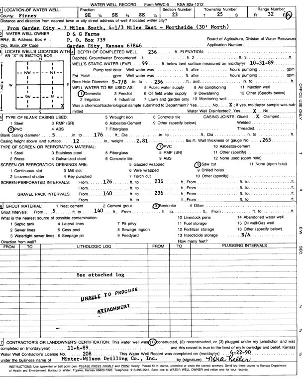
Specific Water Well Detail |
|
|
| Location Info | |||
| Owner: D & G Farms | Status: Constructed | ||
| Location: T25S, R32W, Sec. 23, SE SE SE | County: Finney | ||
| Directions: from Garden City: 7 mi S, 4.3 mi E, and 30 feet N | |||
| Latitude: 37.8592983 | Longitude: -100.7932386 | Datum NAD 27 | |
| Latitude: 37.8593215 | Longitude: -100.7936762 | Datum NAD 83 | |
| Longitude and latitude calculated by Survey from township-range-section-quarter calls. Only good to within the quarter call accuracy. | |||
| View well on interactive map | |||
| General Info | ||
| Well Depth: 236 ft. | Elevation: ft. | |
| Static Water Level: 99 ft. | Est. Yield: gpm. | |
| Comp. Date: 06-Nov-1989 | Well Use: Domestic | |
| DWR Applic. #: | Other ID: | |
| Driller Info | ||
| Driller: MW Drilling | License #: 208 | |
| Scanned Form | View scan |
|
Chemical Sample Submitted?: No
Water Well disinfected?: | ||
| Ground water encountered: 0 ft. , 0 ft. , 0 ft. | ||
| Pump test data: Well water was 0 ft after 0 hours pumping 0 gpm | ||
| Casing Info | ||
| Casing Type: PVC
Casing Joints: |
Diam: 5 in. to 176 ft
Diam: 0 in. to 0 ft Diam: 0 in. to 0 ft | |
| Casing height above land surface: in
Casing Weight: lbs/ft Wall thickness or gauge no.: | ||
| Screen and Perforation Info | ||
| Screen Type: PVC | Screen Openings: Saw cut | |
| Screen-perforated intervals | From: 176 ft to 236 ft
From: 0 ft to 0 ft From: 0 ft to 0 ft | |
| Gravel pack intervals | From: ft to ft | |
| Grout Info | ||
| Grout used: Bentonite | From: 5 to 140 ft
From: 0 to 0 ft From: 0 to 0 ft | |
| Source of Possible Contamination | ||
| Source: OTHER | ||
| Direction from well: | Distance: 0 ft | |
| Lithologic Log
(log data not edited or checked by the KGS.) | ||
| From: 0 ft. to 10 ft. | Type: SANDY CLAY | |
| From: 10 ft. to 39 ft. | Type: SAND & GRAVEL | |
| From: 39 ft. to 93 ft. | Type: SANDY CLAY | |
| From: 93 ft. to 105 ft. | Type: GRAVEL | |
| From: 105 ft. to 120 ft. | Type: SANDY CLAY | |
| From: 120 ft. to 131 ft. | Type: SAND & GRAVEL | |
| From: 131 ft. to 138 ft. | Type: CLAY | |
| From: 138 ft. to 160 ft. | Type: SAND & GRAVEL | |
| From: 160 ft. to 192 ft. | Type: SANDY CLAY | |
| From: 192 ft. to 196 ft. | Type: SAND & GRAVEL | |
| From: 196 ft. to 222 ft. | Type: SANDY CLAY | |
| From: 222 ft. to 237 ft. | Type: SAND & GRAVEL | |
| From: 237 ft. to 240 ft. | Type: SANDY CLAY | |