|
|
|
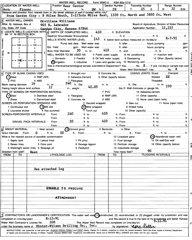
Specific Water Well Detail |
|
|
| Location Info | |||
| Owner: Williams, Orvillene | Status: Constructed | ||
| Location: T25S, R32W, Sec. 28, S | County: Finney | ||
| Directions: from Garden City: 8 mi S, 2.6 mi E, 1320 feet N, and 3850 feet W | |||
| Latitude: 37.8513183 | Longitude: -100.8377495 | Datum NAD 27 | |
| Latitude: 37.8513417 | Longitude: -100.838189 | Datum NAD 83 | |
| Longitude and latitude calculated by Survey from township-range-section-quarter calls. Only good to within the quarter call accuracy. | |||
| View well on interactive map | |||
| General Info | ||
| Well Depth: 410 ft. | Elevation: ft. | |
| Static Water Level: 143 ft. | Est. Yield: gpm. | |
| Comp. Date: 13-Aug-1991 | Well Use: Irrigation | |
| DWR Applic. #: 12225 | Other ID: | |
| Links | |
| No Wizard information available. | |
| View info from WIMAS Water Right Data base... | |
| Driller Info | ||
| Driller: Minter-Wilson Drlg. Co., Inc. | License #: 208 | |
| Scanned Form | View scan |
|
Chemical Sample Submitted?: No
Water Well disinfected?: | ||
| Ground water encountered: 0 ft. , 0 ft. , 0 ft. | ||
| Pump test data: Well water was 0 ft after 0 hours pumping 0 gpm | ||
| Casing Info | ||
| Casing Type: Steel
Casing Joints: |
Diam: 16 in. to 240 ft
Diam: 0 in. to 0 ft Diam: 0 in. to 0 ft | |
| Casing height above land surface: in
Casing Weight: lbs/ft Wall thickness or gauge no.: | ||
| Screen and Perforation Info | ||
| Screen Type: Steel | Screen Openings: Mill slot | |
| Screen-perforated intervals | From: 240 ft to 410 ft
From: 0 ft to 0 ft From: 0 ft to 0 ft | |
| Gravel pack intervals | From: ft to ft | |
| Grout Info | ||
| Grout used: Cement grout | From: 0 to 20 ft
From: 0 to 0 ft From: 0 to 0 ft | |
| Source of Possible Contamination | ||
| Source: Abandoned water well | ||
| Direction from well: | Distance: 0 ft | |
| Lithologic Log
(log data not edited or checked by the KGS.) | ||
| From: 0 ft. to 1 ft. | Type: CLAY | |
| From: 1 ft. to 10 ft. | Type: FINE SAND | |
| From: 10 ft. to 21 ft. | Type: SANDY CLAY | |
| From: 21 ft. to 47 ft. | Type: SAND & GRAVEL | |
| From: 47 ft. to 66 ft. | Type: COARSE GRAVEL | |
| From: 66 ft. to 122 ft. | Type: SAND & GRAVEL | |
| From: 122 ft. to 137 ft. | Type: MEDIUM GRAVEL | |
| From: 137 ft. to 140 ft. | Type: CLAY | |
| From: 140 ft. to 154 ft. | Type: FINE SAND | |
| From: 154 ft. to 181 ft. | Type: SANDY CLAY | |
| From: 181 ft. to 187 ft. | Type: SAND & GRAVEL | |
| From: 187 ft. to 193 ft. | Type: SANDY CLAY | |
| From: 193 ft. to 198 ft. | Type: SAND & GRAVEL | |
| From: 198 ft. to 224 ft. | Type: ROCK & CLAY | |
| From: 224 ft. to 278 ft. | Type: SAND & GRAVEL | |
| From: 278 ft. to 288 ft. | Type: SANDY CLAY | |
| From: 288 ft. to 305 ft. | Type: SAND & GRAVEL | |
| From: 305 ft. to 323 ft. | Type: SANDY CLAY | |
| From: 323 ft. to 329 ft. | Type: SAND & GRAVEL | |
| From: 329 ft. to 358 ft. | Type: SANDY CLAY | |
| From: 358 ft. to 364 ft. | Type: FINE SAND | |
| From: 364 ft. to 376 ft. | Type: SANDY CLAY | |
| From: 376 ft. to 380 ft. | Type: SAND & GRAVEL | |
| From: 380 ft. to 385 ft. | Type: SANDY CLAY | |
| From: 385 ft. to 406 ft. | Type: SAND & GRAVEL | |
| From: 406 ft. to 440 ft. | Type: CLAY | |