|
|
|
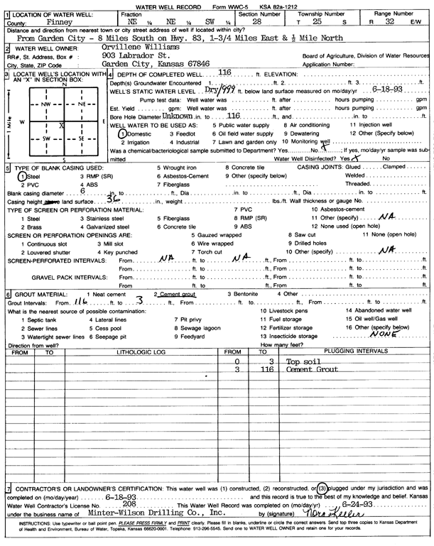
Specific Water Well Detail |
|
|
| Location Info | |||
| Owner: Williams, Orvillene | Status: Plugged | ||
| Location: T25S, R32W, Sec. 28, NE NE SW | County: Finney | ||
| Directions: from Garden City: 8 mi S on Hwy 83, 1.75 mi E, and 0.5 mi N | |||
| Latitude: 37.8504101 | Longitude: -100.8388889 | Datum NAD 27 | |
| Latitude: 37.8504336 | Longitude: -100.8393285 | Datum NAD 83 | |
| Longitude and latitude calculated by Survey from township-range-section-quarter calls. Only good to within the quarter call accuracy. | |||
| View well on interactive map | |||
| General Info | ||
| Well Depth: 116 ft. | Elevation: ft. | |
| Static Water Level: ft. | Est. Yield: gpm. | |
| Comp. Date: 18-Jun-1993 | Well Use: Domestic | |
| DWR Applic. #: | Other ID: | |
| Driller Info | ||
| Driller: Minter-Wilson Drlg. Co., Inc. | License #: 208 | |
| Scanned Form | View scan |
| Casing Info | ||
|
Casing Type: Steel
Diam: 6 in. Casing height above land surface: in | ||
| Grout Info | ||
| Grout used: Cement grout | From: 3 to 116 ft
From: 0 to 0 ft From: 0 to 0 ft | |
| Source of Possible Contamination | ||
| Source: OTHER | ||
| Direction from well: | Distance: 0 ft | |