|
|
|
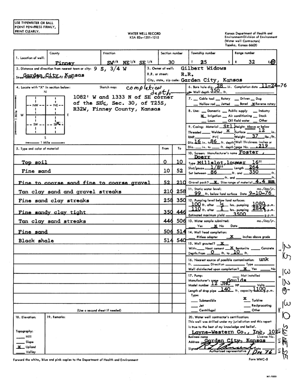
Specific Water Well Detail |
|
|
| Location Info | |||
| Owner: Widows, Gilbert | Status: Constructed | ||
| Location: T25S, R32W, Sec. 30, SW NE SE | County: Finney | ||
| Directions: from Garden City, 9 mi S and 0.75 mi W | |||
| Latitude: 37.8487192 | Longitude: -100.8684783 | Datum NAD 27 | |
| Latitude: 37.8487426 | Longitude: -100.868919 | Datum NAD 83 | |
| Longitude and latitude calculated by Survey from township-range-section-quarter calls. Only good to within the quarter call accuracy. | |||
| View well on interactive map | |||
| General Info | ||
| Well Depth: 350 ft. | Elevation: ft. | |
| Static Water Level: 99 ft. | Est. Yield: 3500 gpm. | |
| Comp. Date: 24-Nov-1976 | Well Use: Irrigation | |
| DWR Applic. #: | Other ID: | |
| Links | |
| View info from Wizard Water Level Data base... | |
| View info from WIMAS Water Right Data base... | |
| Driller Info | ||
| Driller: Layne-Christensen Co. | License #: 102 | |
| Scanned Form | View scan |
|
Chemical Sample Submitted?: No
Water Well disinfected?: | ||
| Ground water encountered: 0 ft. , 0 ft. , 0 ft. | ||
| Pump test data: Well water was 0 ft after 0 hours pumping 0 gpm | ||
| Casing Info | ||
| Casing Type:
Casing Joints: |
Diam: 0 in. to 0 ft
Diam: 0 in. to 0 ft Diam: 0 in. to 0 ft | |
| Casing height above land surface: in
Casing Weight: lbs/ft Wall thickness or gauge no.: | ||
| Screen and Perforation Info | ||
| Screen Type: | Screen Openings: | |
| Screen-perforated intervals | From: 86 ft to 350 ft
From: 0 ft to 0 ft From: 0 ft to 0 ft | |
| Gravel pack intervals | From: ft to ft | |
| Grout Info | ||
| Grout used: | From: 0 to 0 ft
From: 0 to 0 ft From: 0 to 0 ft | |
| Source of Possible Contamination | ||
| Source: | ||
| Direction from well: | Distance: 0 ft | |
| Lithologic Log
(Log data entered by KGS.) | ||
| From: 0 ft. to 10 ft. | top soil | |
| From: 10 ft. to 52 ft. | fine sand | |
| From: 52 ft. to 210 ft. | fine to coarse sand fine to coarse gravel | |
| From: 210 ft. to 258 ft. | tan clay sand and gravel streaks | |
| From: 258 ft. to 350 ft. | fine sand clay streaks | |
| From: 350 ft. to 446 ft. | fine sandy clay tight | |
| From: 446 ft. to 506 ft. | tan clay sand streaks | |
| From: 506 ft. to 514 ft. | fine sand | |
| From: 514 ft. to 540 ft. | black shale | |