|
|
|
Specific Water Well Detail |
|
|
| Location Info | |||
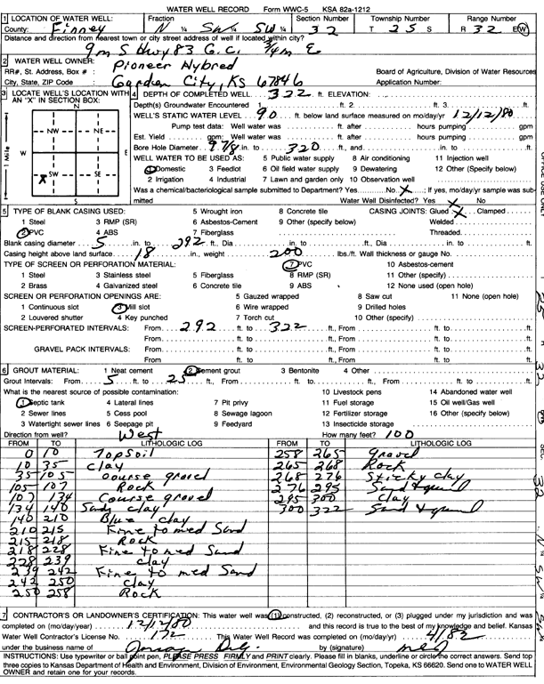
| Owner: Pioneer Hybrid | Status: Constructed | ||
| Location: T25S, R32W, Sec. 32, SW | County: Finney | ||
| Directions: from Garden City, 9 mi S on Hwy 83 and 0.75 mi E | |||
| Latitude: 37.8332194 | Longitude: -100.860555 | Datum NAD 27 | |
| Latitude: 37.8332429 | Longitude: -100.8609956 | Datum NAD 83 | |
| Longitude and latitude calculated by Survey from township-range-section-quarter calls. Only good to within the quarter call accuracy. | |||
| View well on interactive map | |||
| General Info | ||
| Well Depth: 322 ft. | Elevation: ft. | |
| Static Water Level: 90 ft. | Est. Yield: gpm. | |
| Comp. Date: 12-Dec-1980 | Well Use: Domestic | |
| DWR Applic. #: | Other ID: | |
| Driller Info | ||
| Driller: Jonagan Water Well Service | License #: 172 | |
| Scanned Form | View scan |
|
Chemical Sample Submitted?: No
Water Well disinfected?: | ||
| Ground water encountered: 0 ft. , 0 ft. , 0 ft. | ||
| Pump test data: Well water was 0 ft after 0 hours pumping 0 gpm | ||
| Casing Info | ||
| Casing Type:
Casing Joints: |
Diam: 0 in. to 0 ft
Diam: 0 in. to 0 ft Diam: 0 in. to 0 ft | |
| Casing height above land surface: in
Casing Weight: lbs/ft Wall thickness or gauge no.: | ||
| Screen and Perforation Info | ||
| Screen Type: | Screen Openings: | |
| Screen-perforated intervals | From: 292 ft to 322 ft
From: 0 ft to 0 ft From: 0 ft to 0 ft | |
| Gravel pack intervals | From: ft to ft | |
| Grout Info | ||
| Grout used: | From: 0 to 0 ft
From: 0 to 0 ft From: 0 to 0 ft | |
| Source of Possible Contamination | ||
| Source: | ||
| Direction from well: | Distance: 0 ft | |
| Lithologic Log
(Log data entered by KGS.) | ||
| From: 0 ft. to 10 ft. | topsoil | |
| From: 10 ft. to 35 ft. | clay | |
| From: 35 ft. to 105 ft. | coarse gravel | |
| From: 105 ft. to 107 ft. | rock | |
| From: 107 ft. to 134 ft. | coarse gravel | |
| From: 134 ft. to 140 ft. | sandy clay | |
| From: 140 ft. to 210 ft. | blue clay | |
| From: 210 ft. to 215 ft. | fine to medium sand | |
| From: 215 ft. to 218 ft. | rock | |
| From: 218 ft. to 228 ft. | fine to medium sand | |
| From: 228 ft. to 239 ft. | clay | |
| From: 239 ft. to 242 ft. | fine to medium sand | |
| From: 242 ft. to 250 ft. | clay | |
| From: 250 ft. to 258 ft. | rock | |
| From: 258 ft. to 265 ft. | gravel | |
| From: 265 ft. to 268 ft. | rock | |
| From: 268 ft. to 276 ft. | sticky clay | |
| From: 276 ft. to 295 ft. | sand and gravel | |
| From: 295 ft. to 300 ft. | clay | |
| From: 300 ft. to 322 ft. | sand and gravel | |