|
|
|
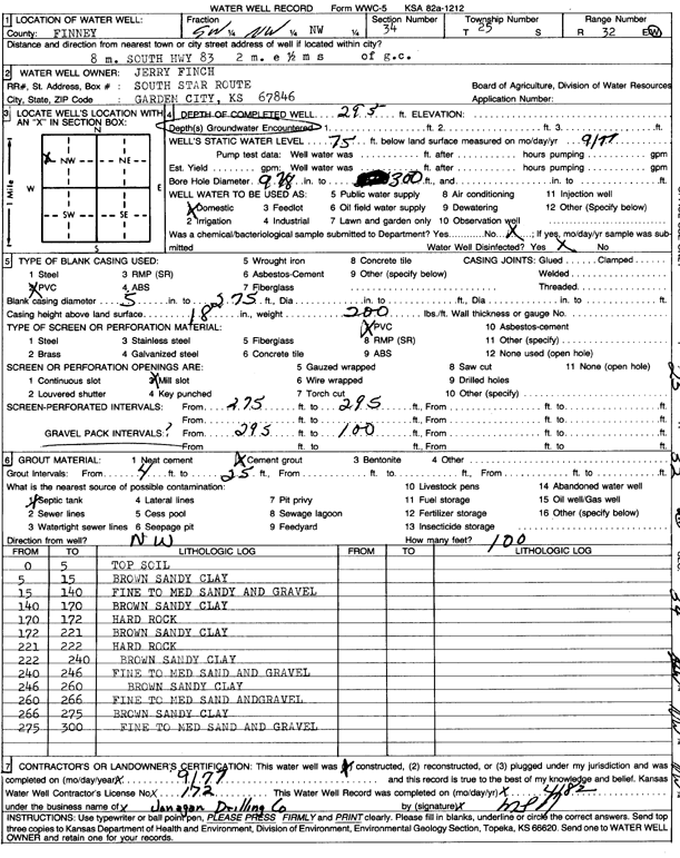
Specific Water Well Detail |
|
|
| Location Info | |||
| Owner: Finch, Jerry | Status: Constructed | ||
| Location: T25S, R32W, Sec. 34, NW | County: Finney | ||
| Directions: 8 mi S on Hwy 83, 2 mi E, .5 mi S of Garden City | |||
| Latitude: 37.840332 | Longitude: -100.8241139 | Datum NAD 27 | |
| Latitude: 37.8403554 | Longitude: -100.824553 | Datum NAD 83 | |
| Longitude and latitude calculated by Survey from township-range-section-quarter calls. Only good to within the quarter call accuracy. | |||
| View well on interactive map | |||
| General Info | ||
| Well Depth: 295 ft. | Elevation: ft. | |
| Static Water Level: 75 ft. | Est. Yield: gpm. | |
| Comp. Date: 01-Sep-1977 | Well Use: Domestic | |
| DWR Applic. #: | Other ID: | |
| Driller Info | ||
| Driller: Jonagan Drilling Co. | License #: 172 | |
| Scanned Form | View scan |
|
Chemical Sample Submitted?: No
Water Well disinfected?: | ||
| Ground water encountered: 0 ft. , 0 ft. , 0 ft. | ||
| Pump test data: Well water was 0 ft after 0 hours pumping 0 gpm | ||
| Casing Info | ||
| Casing Type:
Casing Joints: |
Diam: 0 in. to 0 ft
Diam: 0 in. to 0 ft Diam: 0 in. to 0 ft | |
| Casing height above land surface: in
Casing Weight: lbs/ft Wall thickness or gauge no.: | ||
| Screen and Perforation Info | ||
| Screen Type: | Screen Openings: | |
| Screen-perforated intervals | From: 275 ft to 295 ft
From: 0 ft to 0 ft From: 0 ft to 0 ft | |
| Gravel pack intervals | From: ft to ft | |
| Grout Info | ||
| Grout used: | From: 0 to 0 ft
From: 0 to 0 ft From: 0 to 0 ft | |
| Source of Possible Contamination | ||
| Source: | ||
| Direction from well: | Distance: 0 ft | |
| Lithologic Log
(Log data entered by KGS.) | ||
| From: 0 ft. to 5 ft. | top soil | |
| From: 5 ft. to 15 ft. | brown sandy clay | |
| From: 15 ft. to 140 ft. | fine to medium sandy and gravel | |
| From: 140 ft. to 170 ft. | brown sandy clay | |
| From: 170 ft. to 172 ft. | hard rock | |
| From: 172 ft. to 221 ft. | brown sandy clay | |
| From: 221 ft. to 222 ft. | hard rock | |
| From: 222 ft. to 240 ft. | brown sandy clay | |
| From: 240 ft. to 246 ft. | fine to medium sand and gravel | |
| From: 246 ft. to 260 ft. | brown sandy clay | |
| From: 260 ft. to 266 ft. | fine to medium sand and gravel | |
| From: 266 ft. to 275 ft. | brown sandy clay | |
| From: 275 ft. to 300 ft. | fine to medium sand and gravel | |