|
|
|
Specific Water Well Detail |
|
|
| Location Info | |||
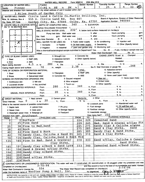
| Owner: Murfin Drilling/Circle Land and Cattle Co. | Status: Constructed | ||
| Location: T25S, R33W, Sec. 4, N2 NE SW | County: Finney | ||
| Directions: from Garden City, 3 mi S | |||
| Latitude: 37.9086229 | Longitude: -100.9492812 | Datum NAD 27 | |
| Latitude: 37.9086467 | Longitude: -100.9497245 | Datum NAD 83 | |
| Longitude and latitude calculated by Survey from township-range-section-quarter calls. Only good to within the quarter call accuracy. | |||
| View well on interactive map | |||
| General Info | ||
| Well Depth: 340 ft. | Elevation: ft. | |
| Static Water Level: 232 ft. | Est. Yield: gpm. | |
| Comp. Date: 10-Mar-1994 | Well Use: Oil Field Water Supply | |
| DWR Applic. #: 940060 | Other ID: | |
| Links | |
| No Wizard information available. | |
| View info from WIMAS Water Right Data base... | |
| Driller Info | ||
| Driller: Jay C. Woofter Pump & Well, Inc. | License #: 554 | |
| Scanned Form | View scan |
|
Chemical Sample Submitted?: No
Water Well disinfected?: | ||
| Ground water encountered: 0 ft. , 0 ft. , 0 ft. | ||
| Pump test data: Well water was 0 ft after 0 hours pumping 0 gpm | ||
| Casing Info | ||
| Casing Type: PVC
Casing Joints: |
Diam: 4 in. to 280 ft
Diam: 0 in. to 0 ft Diam: 0 in. to 0 ft | |
| Casing height above land surface: in
Casing Weight: lbs/ft Wall thickness or gauge no.: | ||
| Screen and Perforation Info | ||
| Screen Type: PVC | Screen Openings: Saw cut | |
| Screen-perforated intervals | From: 280 ft to 340 ft
From: 0 ft to 0 ft From: 0 ft to 0 ft | |
| Gravel pack intervals | From: ft to ft | |
| Grout Info | ||
| Grout used: Bentonite | From: 0 to 20 ft
From: 0 to 0 ft From: 0 to 0 ft | |
| Source of Possible Contamination | ||
| Source: Oil well/gas well | ||
| Direction from well: | Distance: 0 ft | |
| Lithologic Log
(Log data entered by KGS.) | ||
| From: 0 ft. to 2 ft. | surface | |
| From: 2 ft. to 25 ft. | fine sand | |
| From: 25 ft. to 38 ft. | fine to medium sand | |
| From: 38 ft. to 40 ft. | rock | |
| From: 40 ft. to 42 ft. | fine sand and rock | |
| From: 42 ft. to 70 ft. | sandy clay, caliche and sand st | |
| From: 70 ft. to 135 ft. | sandy clay, caliche, sand and rock mix | |
| From: 135 ft. to 185 ft. | fine to medium sand and gravel with clay streaks | |
| From: 185 ft. to 191 ft. | sandy clay with rock and sand layers | |
| From: 191 ft. to 196 ft. | sand and gravel with clay streaks | |
| From: 196 ft. to 200 ft. | sandy clay with sand streaks | |
| From: 200 ft. to 202 ft. | sand | |
| From: 202 ft. to 220 ft. | sand with clay streaks | |
| From: 220 ft. to 224 ft. | rock | |
| From: 224 ft. to 229 ft. | cemented sand | |
| From: 229 ft. to 245 ft. | medium sand and gravel with clay streaks | |
| From: 245 ft. to 275 ft. | sandy clay and caliche with some sand | |
| From: 275 ft. to 285 ft. | sand and clay streaks | |
| From: 285 ft. to 305 ft. | sandy clay and sand streaks | |
| From: 305 ft. to 310 ft. | sand and clay streaks | |
| From: 310 ft. to 333 ft. | sand with clay, caliche and cement sand streaks | |
| From: 333 ft. to 340 ft. | cemented sand with sand streaks | |