|
|
|
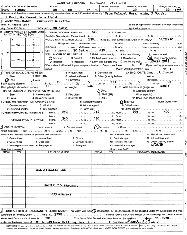
Specific Water Well Detail |
|
|
| Location Info | |||
| Owner: Sunflower Electric Power Corp. | Status: Constructed | ||
| Location: T25S, R33W, Sec. 5, NW NW NW | County: Finney | ||
| Directions: from north side of Holcomb, 5 mi S, 1 mi E, and SE into field | |||
| Latitude: 37.9158671 | Longitude: -100.9733292 | Datum NAD 27 | |
| Latitude: 37.9158911 | Longitude: -100.9737734 | Datum NAD 83 | |
| Longitude and latitude calculated by Survey from township-range-section-quarter calls. Only good to within the quarter call accuracy. | |||
| View well on interactive map | |||
| General Info | ||
| Well Depth: 420 ft. | Elevation: ft. | |
| Static Water Level: 128 ft. | Est. Yield: gpm. | |
| Comp. Date: 04-May-1990 | Well Use: Domestic, Livestock | |
| DWR Applic. #: | Other ID: | |
| Driller Info | ||
| Driller: Minter-Wilson Drlg. Co., Inc. | License #: 208 | |
| Scanned Form | View scan |
|
Chemical Sample Submitted?: No
Water Well disinfected?: | ||
| Ground water encountered: 0 ft. , 0 ft. , 0 ft. | ||
| Pump test data: Well water was 0 ft after 0 hours pumping 0 gpm | ||
| Casing Info | ||
| Casing Type: PVC
Casing Joints: |
Diam: 5 in. to 293 ft
Diam: 5 in. to 333 ft Diam: 5 in. to 390 ft | |
| Casing height above land surface: in
Casing Weight: lbs/ft Wall thickness or gauge no.: | ||
| Screen and Perforation Info | ||
| Screen Type: PVC | Screen Openings: Saw cut | |
| Screen-perforated intervals | From: 293 ft to 313 ft
From: 390 ft to 420 ft From: 0 ft to 0 ft | |
| Gravel pack intervals | From: ft to ft | |
| Grout Info | ||
| Grout used: Bentonite | From: 0 to 260 ft
From: 0 to 0 ft From: 0 to 0 ft | |
| Source of Possible Contamination | ||
| Source: OTHER | ||
| Direction from well: | Distance: 0 ft | |
| Lithologic Log
(log data not edited or checked by the KGS.) | ||
| From: 0 ft. to 1 ft. | Type: CLAY | |
| From: 1 ft. to 33 ft. | Type: FINE SAND | |
| From: 33 ft. to 57 ft. | Type: SAND | |
| From: 57 ft. to 61 ft. | Type: CLAY | |
| From: 61 ft. to 72 ft. | Type: SAND | |
| From: 72 ft. to 83 ft. | Type: CLAY | |
| From: 83 ft. to 98 ft. | Type: SAND & GRAVEL | |
| From: 98 ft. to 106 ft. | Type: CLAY | |