|
|
|
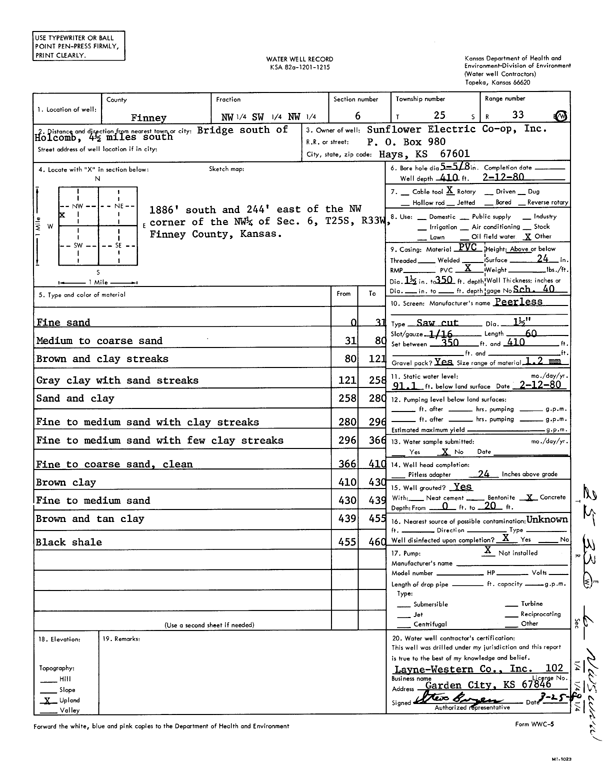
Specific Water Well Detail |
|
|
| Location Info | |||
| Owner: Sunflower Electric Power Corp. | Status: Constructed | ||
| Location: T25S, R33W, Sec. 6, NW SW NW | County: Finney | ||
| Directions: from S of Holcomb, 4.5 mi S of bridge | |||
| Latitude: 37.9121079 | Longitude: -100.9912496 | Datum NAD 27 | |
| Latitude: 37.9121319 | Longitude: -100.9916946 | Datum NAD 83 | |
| Longitude and latitude calculated by Survey from township-range-section-quarter calls. Only good to within the quarter call accuracy. | |||
| View well on interactive map | |||
| General Info | ||
| Well Depth: 410 ft. | Elevation: ft. | |
| Static Water Level: 91.1 ft. | Est. Yield: gpm. | |
| Comp. Date: 12-Feb-1980 | Well Use: Other | |
| DWR Applic. #: | Other ID: | |
| Links | |
| View info from Wizard Water Level Data base... | |
| No WIMAS information available. | |
| Driller Info | ||
| Driller: Layne-Christensen Co. | License #: 102 | |
| Scanned Form | View scan |
|
Chemical Sample Submitted?: No
Water Well disinfected?: | ||
| Ground water encountered: 0 ft. , 0 ft. , 0 ft. | ||
| Pump test data: Well water was 0 ft after 0 hours pumping 0 gpm | ||
| Casing Info | ||
| Casing Type:
Casing Joints: |
Diam: 0 in. to 0 ft
Diam: 0 in. to 0 ft Diam: 0 in. to 0 ft | |
| Casing height above land surface: in
Casing Weight: lbs/ft Wall thickness or gauge no.: | ||
| Screen and Perforation Info | ||
| Screen Type: | Screen Openings: | |
| Screen-perforated intervals | From: 350 ft to 410 ft
From: 0 ft to 0 ft From: 0 ft to 0 ft | |
| Gravel pack intervals | From: ft to ft | |
| Grout Info | ||
| Grout used: | From: 0 to 0 ft
From: 0 to 0 ft From: 0 to 0 ft | |
| Source of Possible Contamination | ||
| Source: | ||
| Direction from well: | Distance: 0 ft | |
| Lithologic Log
(Log data entered by KGS.) | ||
| From: 0 ft. to 31 ft. | fine sand | |
| From: 31 ft. to 80 ft. | medium to coarse sand | |
| From: 80 ft. to 121 ft. | brown and clay streaks | |
| From: 121 ft. to 258 ft. | gray clay with sand streaks | |
| From: 258 ft. to 280 ft. | sand and clay | |
| From: 280 ft. to 296 ft. | fine to medium sand with clay streaks | |
| From: 296 ft. to 366 ft. | fine to medium sand with few clay streaks | |
| From: 366 ft. to 410 ft. | fine to coarse sand, clean | |
| From: 410 ft. to 430 ft. | brown clay | |
| From: 430 ft. to 439 ft. | fine to medium sand | |
| From: 439 ft. to 455 ft. | brown and tan clay | |
| From: 455 ft. to 460 ft. | black shale | |