|
|
|
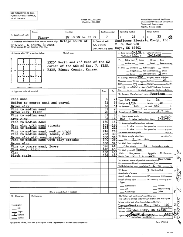
Specific Water Well Detail |
|
|
| Location Info | |||
| Owner: Sunflower Electric Power Corp. | Status: Constructed | ||
| Location: T25S, R33W, Sec. 7, SW NW SE | County: Finney | ||
| Directions: 6 S of bridge S of Holcomb, .5 E | |||
| Latitude: 37.8921466 | Longitude: -100.9823503 | Datum NAD 27 | |
| Latitude: 37.8921706 | Longitude: -100.9827951 | Datum NAD 83 | |
| Longitude and latitude calculated by Survey from township-range-section-quarter calls. Only good to within the quarter call accuracy. | |||
| View well on interactive map | |||
| General Info | ||
| Well Depth: 440 ft. | Elevation: ft. | |
| Static Water Level: 102 ft. | Est. Yield: gpm. | |
| Comp. Date: 11-Feb-1980 | Well Use: Other | |
| DWR Applic. #: | Other ID: | |
| Links | |
| View info from Wizard Water Level Data base... | |
| No WIMAS information available. | |
| Driller Info | ||
| Driller: Layne-Christensen Co. | License #: 102 | |
| Scanned Form | View scan |
|
Chemical Sample Submitted?: No
Water Well disinfected?: Yes | ||
| Ground water encountered: 0 ft. , 0 ft. , 0 ft. | ||
| Pump test data: Well water was 0 ft after 0 hours pumping 0 gpm | ||
| Bore hole diameter: 5.88 inches to ft | ||
| Casing Info | ||
| Casing Type: PVC
Casing Joints: |
Diam: 1.5 in. to 400 ft
Diam: 0 in. to 0 ft Diam: 0 in. to 0 ft | |
| Casing height above land surface: 24 in
Casing Weight: lbs/ft Wall thickness or gauge no.: Schd 40 | ||
| Screen and Perforation Info | ||
| Screen Type: | Screen Openings: Saw cut | |
| Screen-perforated intervals | From: 400 ft to 440 ft
From: 0 ft to 0 ft From: 0 ft to 0 ft | |
| Gravel pack intervals | From: ft to ft | |
| Grout Info | ||
| Grout used: | From: 0 to 0 ft
From: 0 to 0 ft From: 0 to 0 ft | |
| Source of Possible Contamination | ||
| Source: Unknown | ||
| Direction from well: | Distance: 0 ft | |
| Lithologic Log
(Log data entered by KGS.) | ||
| From: 0 ft. to 21 ft. | fine sand | |
| From: 21 ft. to 36 ft. | medium to coarse sand and gravel | |
| From: 36 ft. to 51 ft. | brown clay | |
| From: 51 ft. to 70 ft. | fine to medium sand | |
| From: 70 ft. to 81 ft. | brown clay, tight | |
| From: 81 ft. to 96 ft. | fine to medium sand | |
| From: 96 ft. to 150 ft. | gray clay | |
| From: 150 ft. to 162 ft. | fine to medium sand | |
| From: 162 ft. to 188 ft. | gray clay with sand streaks | |
| From: 188 ft. to 216 ft. | fine to medium sand | |
| From: 216 ft. to 268 ft. | fine to medium sand, medium tight | |
| From: 268 ft. to 300 ft. | fine to medium sand, loose, clean | |
| From: 300 ft. to 340 ft. | brown clay with sand streaks | |
| From: 340 ft. to 360 ft. | fine to medium sand with clay streaks | |
| From: 360 ft. to 396 ft. | brown clay | |
| From: 396 ft. to 440 ft. | fine to coarse sand, loose | |
| From: 440 ft. to 450 ft. | fine sand, tight | |
| From: 450 ft. to 456 ft. | clay | |
| From: 456 ft. to 460 ft. | black shale | |